The latest weather forecast warned of isolated tornadoes and flooding risks in the South-Central US.
Meanwhile, the Western US can anticipate heavy precipitation and cooler air conditions.
Recently, Southern and Central US experienced challenging heat conditions due to the scorching heat in the region.
This week, there is a relief from the heat.
However, residents can anticipate severe weather risks. Potentially isolated tornadoes and damaging winds could unfold.
South-Central US Weather: Cooler air and severe weather conditions
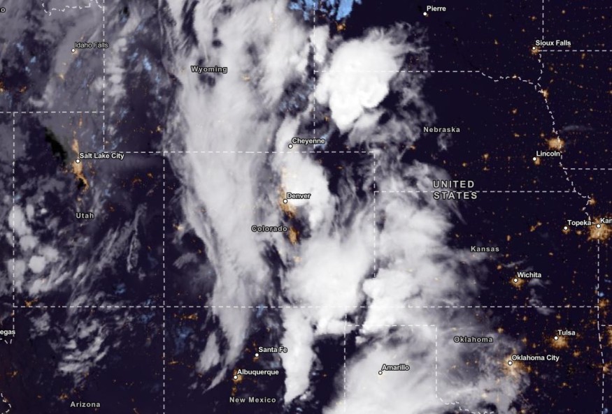
In the recent report, NWN warned of the excessive rainfall in the Southern Plains, Central Plains and Midwest. The challenging weather conditions could bring severe thunderstorms on Tuesday, causing flooding and flash flood concerns.
Meanwhile, the weather pattern change in the South-Central US can unleash troublesome weather outlooks for many residents.
According to the latest forecast, residents can expect severe weather threats on Tuesday.
In the midweek, large hail, thunderstorms and potentially isolated tornadoes can unload in the following areas:
- Sioux Falls
- North Platte
- Omaha
- Topeka
- Wichita
- Oklahoma City
- Amarillo
- Lubbock
- Midland
- Kansas
- Texax
- Eastern Nebraska
The rainy conditions can benefit the drought-stricken areas, especially in Texas and Kansas.
On Wednesday, the damaging wind gusts could reach from 60 to 70 mph, with chances of flash floods in the following areas:
- Oklahoma City
- Dallas
- San Antonio
- Odessa
In Kansas City, the latest advisory reported a gradual cooldown in temperatures in the region. However, residents should watch out for thunderstorm dangers on Tuesday night or Wednesday morning.
Starting Wednesday, the weather conditions can change in the South-Central US. Beneficial heavy rain can be unleashed in the following areas:
- Wichita
- Oklahoma City
- Amarillo
- Lubbock
- Odessa
- Dallas
- San Antonio
- Houston
- Little Rock
Meanwhile, the National Weather Service (NWS) added that the stormy conditions could decrease on Wednesday.
The poor weather conditions could reach Northwestern Louisiana, Southwestern Missouri, Western Arkansas, Northeastern Texas and the Western Gulf Coast.
Americans with outdoor activities should consider the weather due to possible travel concerns and road disruptions. Motorists should stay alert for flash flood risks and flooded roads.
Also Read : Excessive Rainfall, Severe Thunderstorms to Unload in Midwest, Central, Southern Plains, Forecast Warns
Western US: Cooler conditions and heavy rain outlook
In the Pacific Northwest and Northern California, heavy rain conditions are due to upper-level troughing. The high-elevation snow is likely in the Northern Rockies.
Residents can anticipate the much-awaited cooler conditions in the Western US, bringing from 10 to 15 below-average temperatures in portions of the Northern Rockies, Great Basin and Northern Intermountain Region.
Furthermore, the Western US is expected to experience prolonged chilly air this October.
Homeowners in low-lying places are at risk of flooding rainfall in the South-Central US and Western US. People should keep updated with the latest weather forecasts in the affected areas this week.
Related Article : US Weather Forecast: Severe Storms To Hit New Mexico, West Texas This Week; Unusual Warmth to Stay in Central US
For more similar stories, don't forget to follow Nature World News.
© 2026 NatureWorldNews.com All rights reserved. Do not reproduce without permission.


