Weather experts said that Tropical Storm Tammy has developed into a tropical storm in the central Atlantic.
Due to this, Tammy is seen to bring torrential rains and massive winds in the Caribbean.
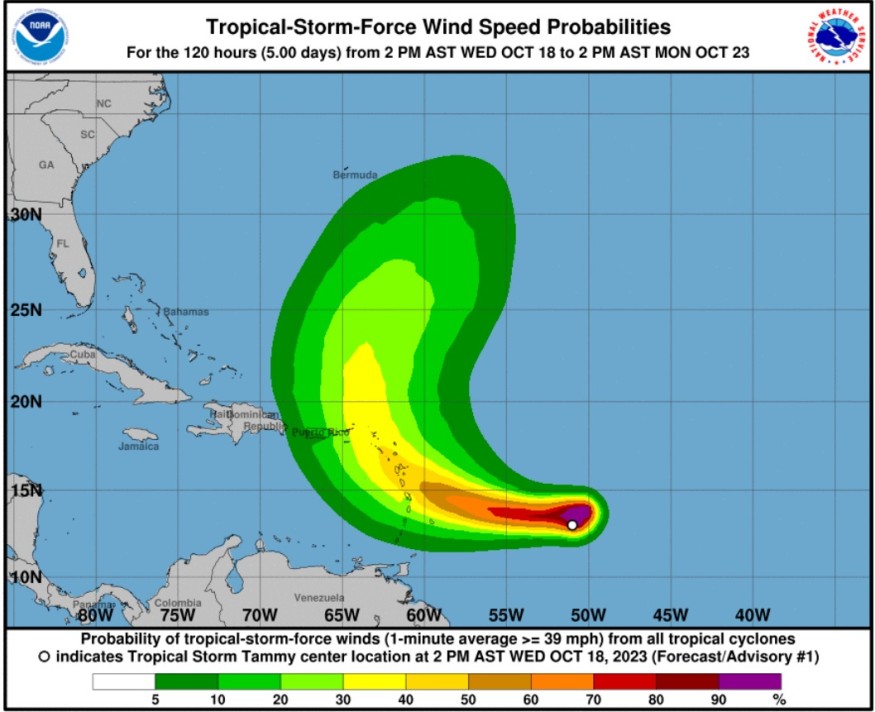
Weather Forecast For Tammy
According to the National Hurricane Center and Central Pacific Hurricane Center, it was at 800 PM AST (0000 UTC) when the center of Tropical Storm Tammy was located near latitude 13.0 North, longitude 52.5 West.
Tammy heading quickly towards the direction of the west near 23 mph (37 km/h). Meanwhile, a westward motion at a slower forward speed is expected on Thursday.
On the other hand, a turn toward the west-northwest has been forecasted by Thursday night, followed by a turn toward the northwest Friday night or Saturday.
Meteorologists said that the center of Tammy will move near or over the Leeward Islands on Friday and Saturday.
Tammy's maximum sustained winds are near 40 mph (65 km/h) with higher gusts.
Based on the forecast, there could be gradual strengthening during the next couple of days.
Further, the tropical-storm-force winds could extend outward up to 140 miles (220 km) from the center.
The estimated minimum central pressure is 1007 mb (29.74 inches).
When it comes to the wind, ropical storm conditions are possible within the watch area beginning on Friday.
Meanwhile, through Saturday night, Tammy is expected to produce storm total rainfall of 3 to 6 inches, with maximum amounts of 10 inches, across portions of the northern Windward into the Leeward Islands.
The rainfall totals of 1 to 2 inches with maximum amounts of 4 inches are also expected for the British and US Virgin Islands into eastern Puerto Rico. Weather experts warned that these rains may produce isolated flash and urban flooding, along with isolated mudslides in areas of higher terrain.
On the other hand, the surf swells generated by Tammy will begin affecting portions ofthe Lesser Antilles on Thursday. Meteorologists warned that these swells are likely to cause life-threatening surf and rip current conditions.
Following these weather developments, a tropical storm watch is in effect for Barbados, Dominica, as well as in Martinique and Guadeloupe
A tropical storm watch means that tropical storm conditions are possible within the watch area, generally within 48 hours.
Additional watches and warnings will likely be required later tonight or on Thursday.
Effects Toward Caribbean
Meanwhile, weather experts said that there is the likelihood of heavy rains, which could lead to incidents of flash floods, mudslides and washouts in the Lesser Antilles, especially across the Leeward Islands of the northeastern Caribbean from Friday to Sunday.
They said that wind gusts of 40-60 mph are likely in the Leeward Islands.
Further sporadic power outages and downed trees are possible because of the winds of that magnitude.
So far, the 2023 Atlantic hurricane season has been busy with 19 named storms in the list.
Weather experts said that there is about a month and a half remaining of the official season, which will end on November 30.
Related Article : Tropical Depression Sean 'Poorly Organized' Over Central Atlantic; May Lose Wind Intensity In The Next Days
Related Video:
© 2026 NatureWorldNews.com All rights reserved. Do not reproduce without permission.


