Forecasts revealed that Tropical Storm Orlene is expected to pound Mexico with heavy rains and gusty winds, causing small to massive flooding.
Residents are advised to keep updated with the weather update.
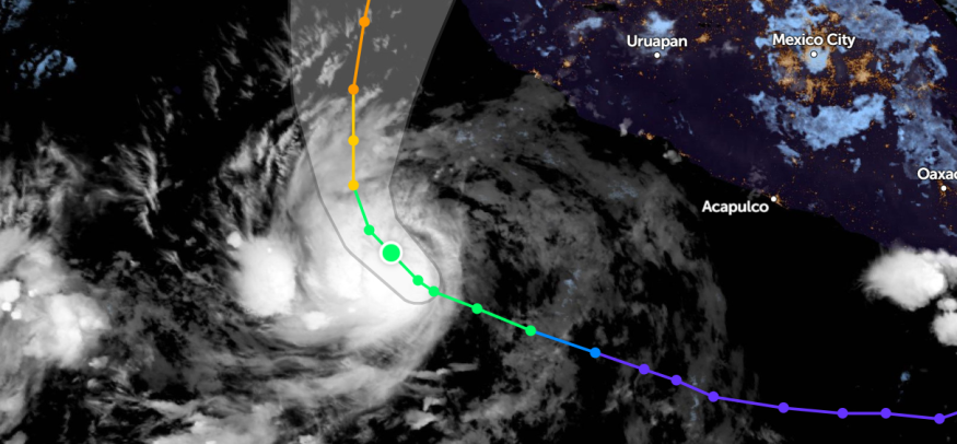
Tropical Storm Orlene is the 16th storm of the East Pacific Hurricane Season and is said to approach the United States.
According to the recent weather updates on September 30, AccuWeathe said that Tropical Storm Orlene could become the ninth hurricane in the season.
The tropical storm is expected to gain more power as it moves to Mexico's southwestern coast.
- On Thursday, the weather website said that Tropical Storm Orlene maintained 45 mph (72 km/h) sustained winds.
- Orlene was seen in the south-southwest of Manzanillo, Mexico, about 290 miles (465 km).
- Sinaloa, Durango and Chihuahua could experience heavy rains.
- Tropical Storm Orlene is rated one on AccuWeather RealImpactTM Scale for Hurricanes in Mexico.
Impact
AccuWeather reported that Orlene's impacts from Friday Night to Tuesday are: damaging winds, mudslides, flash flooding, and rough seas.
The brunt of the tropical storm system could start on Friday and worsens on the weekend.
Tropical Storm Orlene could unleash two to four inches of rain in Sinaloa, Durango, and Chihuahua areas, causing rainfall flooding and flash flooding concerns in communities.
Moreover, AccuWeather revealed that Tropical Storm Orlene's wind gusts could reach:
- Jalisco, Nayarit, and Durango areas could experience 40-60 mph (60-100 km/h) wind gusts.
- Portions of Sinaloa and Dunrago could also feel much stronger wind gusts reaching 60-80 mph (100-130 km/h).
- Tropical Storm Orlene is on the AccuWeather Local StormMaxTM of 100 mph.
Furthermore, forecasts said Tropical Storm Orlene could unload moisture affecting the Southwestern states.
It could aggravate downpours leading to flash flood threats.
Residents affected should prepare for possible flooding and stronger wind gusts.
On the other hand, NOAA NWS National Hurricane Center, Hurricane Ian is expected to hit South Carolina and Georgia with potential rainfall, flooding, storm surge, and strong winds.
Tropical Storm Preparations
As Tropical Storm Orlene is set to hit western parts of Mexico, reports showed that the heavy rains and strong winds could threaten residents.
Here are some reminders before Tropical Storm Orlene makes landfall.
- Stay updated with the current weather updates from local and national news agencies.
- Keep enough supply of food. Prepare an emergency bag containing basic food, primary documentation, and a power bank or radio in case local authorities announce an evacuation.
- Refrain from traveling to areas with Tropical Storm Signal or Watch. Roads could be closed due to downed trees, flooding, landslides, or zero visibility.
- Check your home for potential damage that can the tropical storm exacerbate. Keep electric wires or equipment at places unreachable to flooding.
- Follow your local authorities' announcement for possible evacuations if the tropical storm worsens.
- After the tropical storm, check yourself again for injuries and home for storm damages.
- Avoid outdoor activities as the tropical storm is set to hit Friday night.
- Ultimately, fully charge your mobile gadgets.
Related Article : Florida Deploys National Guard; Millions Ordered to Evacuate as Hurricane Ian Draws Near
For more similar stories, don't forget to follow Nature World News.
© 2026 NatureWorldNews.com All rights reserved. Do not reproduce without permission.


