Thunderstorms have caused widespread damage in some portions of the United States since the onset of the spring season on March 20, especially over the Central US and Southern US.
This week, severe thunderstorm warnings have been issued by weather authorities for the states of Wisconsin and Texas.
In addition to the severe weather, the continuance of fire weather and wildfires is still looming in the Southwest US and the southern High Plains.
Since April, multiple agricultural areas in the region have been engulfed in flames in addition to the dry conditions, strong winds, and above-normal temperatures.
Thunderstorm Warning
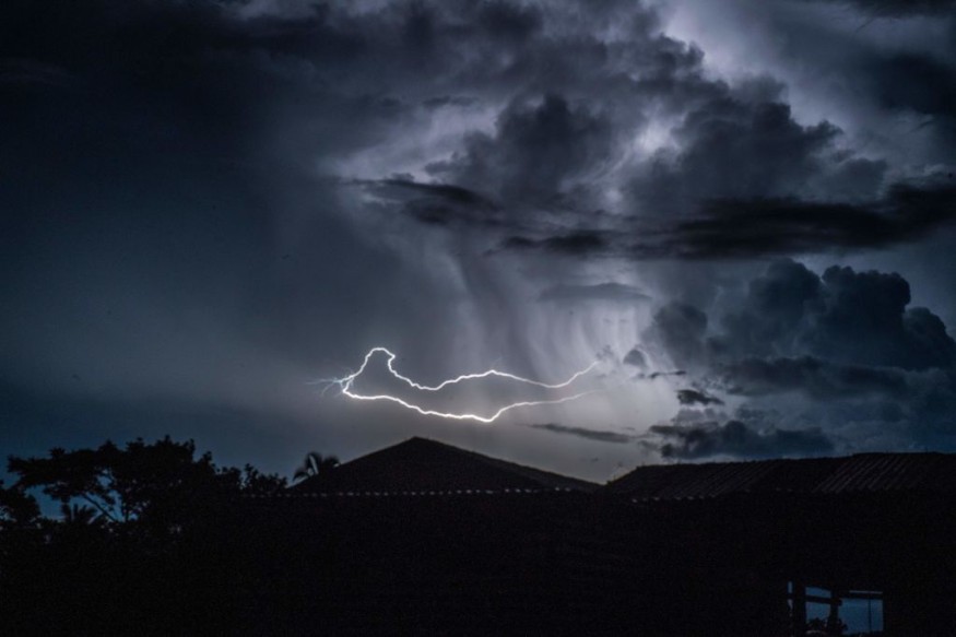
In its latest US weather forecast, the Weather Prediction Center (WPC) of the National Oceanic and Atmospheric Administration (NOAA) - National Weather Service (NWS), on Tuesday, May 10, has issued severe thunderstorm warnings for some portions of Wisconsin and western Texas.
The thunderstorms are likely to be associated with heavy rain, damaging winds, large hail, and the formation of tornadoes.
These conditions have also been forecasted from the Midwest to the Southern High Plains prior to a strengthening storm system.
The warning will be valid from Wednesday to Friday, May 11 to May 13. However, previous weather advisories of the US weather agency have been subjected to updates.
Thus, additional weather-related information may be consolidated in the coming days.
Midwest and Southern High Plains
The NOAA - NWS placed a warning for "Slight Risk," the second out of a four-tier scale, of excessive rainfall for parts of the Upper Missouri and Mississippi Valleys on Wednesday.
This is due to the deep moisture and warm front being carried northward across the region, leading to torrential rain.
Due to the heavy downpour, flash floods or widespread flooding are possible in low-lying areas and communities near lakes or rivers in the said region.
Since the rainfall is correlated with adverse weather, the Storm Prediction Center (SPC) has also issued a Slight Risk for Severe Thunderstorms, the second out of a five-tier scale, for the said two regions.
In addition, the US storm agency gave an "Enhanced Risk," the third on the scale, for a robust thunderstorm across a vast area of the Northern Plains and Upper Midwest on Thursday, May 12.
This is due to the deepening of a reported surface low moving into the region.
Summer Heat
In another weather advisory, the WPC, in its short-range forecast of a "summer-like heat" expanding in a northward pattern across the Midwest and Northeast.
It also mentioned critical fire dangers are still persisting from the Southwest US to the High Plains.
In particular, the extreme heat over the Heartland region will spread to the Midwest and Interior Northeast on Wednesday and Thursday.
Meanwhile, a lingering surface low over the Atlantic Ocean will continue to bring cool temperatures along the East Coast.
Wildfires
For the southwestern and southern states, fire weather conditions continue to pose a risk of wildfire formations and growth.
According to a video report of ABC News, over a dozen wildfires are burning across the Southwest, including the new '"Cerro Pelado Fire" in New Mexico.
The emergence of the novel fire came as the state is still dealing with the Calf Canyon Fire since April 6, resulting in the destruction of at least 276 structures and evacuation of almost 13,000 residences but with no reported deaths, according to The Washington Post.
© 2026 NatureWorldNews.com All rights reserved. Do not reproduce without permission.


