Coastal cities worldwide confront escalating dangers from rising seas linked to climate change. Places like Miami, Jakarta, and Shanghai already deal with routine tidal flooding, signaling broader vulnerabilities ahead.
Cities Most at Risk from Rising Seas
Vulnerable urban centers cluster along low-lying shores, where even small sea level increases trigger widespread disruption. Miami sees over 10 high-tide flood days yearly, up sharply from decades ago. New Orleans grapples with subsidence amplifying surge risks, while densely packed Mumbai and Dhaka house tens of millions in harm's way.
Interactive sea level rise maps paint a grim picture—red zones mark submersion risks for ports from New York to Ho Chi Minh City by mid-century. NOAA's viewer, for instance, projects daily inundation across U.S. coasts under moderate warming paths. Globally, nearly a billion people occupy zones under 10 meters elevation, facing displacement without action.
Key hotspots include:
- Miami, Florida: Frequent "sunny day" floods disrupt traffic and businesses.
- Jakarta, Indonesia: Sinking land plus 15 cm rise since 1990 prompts a sea wall mega-project.
- Shanghai, China: Yangtze Delta homes 60 million, with dikes holding back tides for now.
- Rotterdam, Netherlands: Early adopter of floating infrastructure.
These areas highlight how climate change flooding compounds urban pressures, from infrastructure strain to economic hits estimated at trillions by 2050.
Drivers Behind Sea Level Rise and Flooding
Global sea levels climbed 20-25 cm since 1900, accelerating to 3.7 mm annually today due to ice melt and ocean warming. Greenland sheds ice at rates six times higher than in the 1990s, dumping billions of tons yearly into the Atlantic.
Thermal expansion—warmer water spreading out—accounts for nearly half the rise. Climate change flooding ties in as heated air fuels fiercer storms, with rainfall intensity up 7% per degree Celsius of warming. Hurricane Harvey dumped 1.5 meters on Houston in 2017, a deluge made three times likelier by human influence.
Satellites from NASA's Jason series confirm no pause in the uptick, with projections of 30-75 cm by 2100 under current emissions. Coastal cities bear the brunt as barriers like reefs degrade.
Ocean Acidification Effects on Marine Life
Oceans soak up a quarter of CO2 emissions, dropping pH by 0.1 units since pre-industrial times—a 30% acidity surge. Ocean acidification effects ravage shell-formers: pteropods, vital krill food, show shell dissolution after weeks in lab tests.
Corals bleach and crumble, slashing reef coverage 14% since 2009. Fisheries suffer as larval fish survival plummets 20-40% in acidic waters, hitting coastal economies reliant on seafood. NOAA reports link this to weakened natural wave buffers, worsening erosion and floods.
- Shellfish like oysters face calcification drops of 25-30%.
- Plankton chains disrupt, starving fish stocks.
- Economic toll: $1 billion yearly U.S. losses projected by 2100.
These shifts interconnect with sea rise, as dying ecosystems lose protective roles against climate change flooding.
Coastal Erosion Solutions and Adaptations
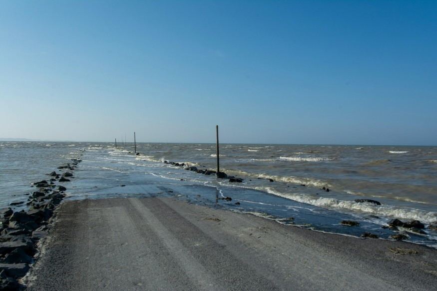
Shorelines retreat 0.5 meters yearly on average, devouring beaches and cliffs. Storms accelerate this, stripping 10-20 meters in single events at exposed sites.
Coastal erosion solutions split into hard, soft, and hybrid tactics:
- Hard engineering: Seawalls and rock revetments shield assets but cost $10,000+ per meter and scour adjacent sands; lifespan 50+ years, low biodiversity gain; example: Netherlands' Delta Works.
- Soft approaches: Beach nourishment pumps dredged sand to rebuild profiles, sustaining tourism; cost medium ($5k/m), lifespan 5-10 years, medium biodiversity; mangroves cut wave energy 50-70%; Florida restored 1,000 hectares.
- Hybrid innovations: Living breakwaters seed oysters on concrete bases, fostering reefs that absorb swells while boosting biodiversity; cost medium-high, lifespan 20-30 years, very high biodiversity; New York's project spans 2 km offshore.
A Causeartist article details how vegetation outperforms concrete long-term by adapting naturally. Wetlands restoration, like Louisiana's $50 billion push, rebuilds buffers absorbing 1.5 cm rise per decade.
Adaptation Tactics for Urban Resilience
Cities pivot to multifaceted defenses. Singapore's 50 km polders enclose land from tides, while Miami elevates 100 miles of roads. Managed retreat buys out 10,000 Florida homes from flood zones.
Sea level rise maps guide zoning—tools overlay risks on property data for smarter planning. Early warnings via apps cut fatalities 30% in test regions. Green infrastructure, from permeable pavements to urban forests, slashes runoff 40%.
Rotterdam's water squares double as parks and basins, holding storm surges. Globally, 70+ solutions cataloged by Ocean-climate.org blend protection with nature. Emission cuts remain key—halving CO2 by 2030 caps rise at 0.5 meters.
Near-term, 10-20 flood days loom by 2030 for East Coast U.S. spots. By 2050, 30 cm average rise submerges 150,000 km² of urban land without barriers.
Charting a Resilient Coastal Future
Forward-thinking cities layer coastal erosion solutions with emission reductions to temper threats. Tools like sea level rise maps arm planners, while ocean acidification effects spur ocean health initiatives. Blending local defenses and global action secures shorelines for generations ahead.
Frequently Asked Questions
1. Is sea level rise accelerating?
Yes, the rate has doubled from 1.5 mm/year in the early 1900s to about 3.7 mm/year today, driven by faster ice melt and warming oceans.
2. Which cities face the highest risks?
Miami, Jakarta, Shanghai, and New Orleans top lists due to low elevation, subsidence, and storm exposure—sea level rise maps show routine flooding by 2050.
3. What causes sea level rise?
Two main factors: melting land ice (Greenland, Antarctica) adds water volume, while thermal expansion from warmer seas increases ocean height—about half from each.
© 2026 NatureWorldNews.com All rights reserved. Do not reproduce without permission.


