The latest weather forecasts reveal that some parts of the United States are still at risk of experiencing isolated severe weather events from Saturday to Monday, April 2 to April 4, affecting areas in the Florida Peninsula, the northern-central Great Plains, and the Pacific Northwest.
Weather Forecast
The Weather Prediction Center of the National Oceanic and Atmospheric Administration (NOAA) - National Weather Service (NWS) issued several weather advisories that are valid from Sunday to Tuesday, April 3 to April 5.
The advisories contain forecasts extending not only from the aforementioned regions but also to the Great Lakes and the Northeast.
Florida Panhandle
Under the advisories, the current storm system will continue to bring severe thunderstorms to most parts of central Florida on Saturday evening.
Over recent days, the system has been responsible for heavy rain due to shortwave energy.
However, it is expected to dissipate in the state by Sunday morning.
In addition, a so-called "quasi-stationary front" will reportedly linger the system's aftermath, causing isolated torrential rain from the central to the southern areas of Florida.
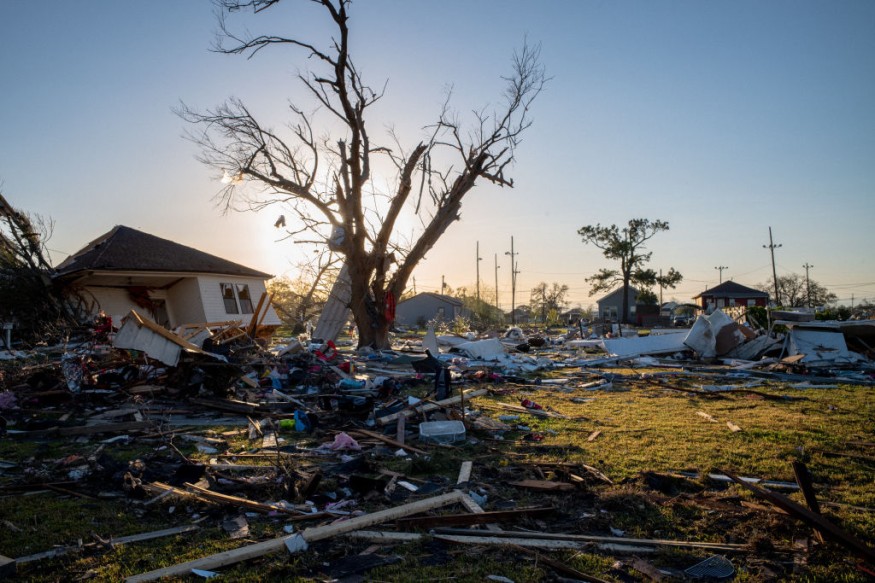
The state has been a scene of devastating severe weather over recent days.
On Thursday, March 31, thunderstorms spawned a tornado that killed two people and injured several people after the twister destroyed some buildings in the Florida Panhandle, as per The New York Times.
The said windstorm is one of the many tornadoes that struck seven states during this week.
Pacific Northwest
In the Pacific Northwest, the NOAA - NWS says a weather disturbance will move toward the region later on Sunday until Monday, bringing heavy precipitation and windy conditions with the chance of torrential rain and flooding.
The adverse weather conditions are caused by a potent low-pressure system that will arrive by Sunday morning, bringing a downpour of heavy snow over the northern-southern Cascade Mountain range and the northern Rockies on Monday.
The occurrences of heavy rain and scattered thunderstorms are also possible in low-altitude areas in the region.
The Great Plains
The US weather agency also highlights the risk of critical fire weather conditions in the northern-central parts of the Great Plains on Sunday.
These weather and climatic conditions can aggravate the growth and spread of wildfires.
On the other hand, the forecast suggested that a new system from the Rockies will descend to the Southern Plains by Sunday afternoon, causing isolated thunderstorms in eastern Texas and central Mississippi until Monday evening.
Furthermore, flash flood due to heavy rainfall is also possible in some parts of southern Arkansas, northern Louisiana, central Oklahoma, western Mississippi, and northeastern Texas.
Eastern US Storm System
A weather disturbance that has been forecasted earlier to affect the Eastern US over the weekend, as per Fox 5 New York, will cause a weak surface low-pressure system through the Ohio Valley and Northeast from Saturday evening to Sunday.
The same storm system has been attributed to causing several injuries, widespread damage, and disruption in multiple states across the Central US and Southern US before the weekend. Thunderstorms associated with the system have resulted in the formation of tornadoes and damaging winds.
© 2026 NatureWorldNews.com All rights reserved. Do not reproduce without permission.


