Switzerland has trail markers every few hundred meters. Not rough cairns or faded paint blazes—actual metal signs with arrows, place names, distances, and estimated walking times.
The Yellow Signs Are Everywhere
Switzerland has trail markers every few hundred meters. Not rough cairns or faded paint blazes—actual metal signs with arrows, place names, distances, and estimated walking times. They're mounted on posts at every junction, crossroads, and potential decision point.
This isn't accidental. Switzerland invested decades building a standardized, nationwide trail marking system. The result is that getting seriously lost requires genuine effort or deliberate disregard for obvious information.
Three Colors Tell You Everything
Swiss trails use a color-coded system that instantly communicates difficulty. Yellow markers indicate hiking trails—well-maintained paths suitable for anyone with basic fitness. White-red-white markers mean mountain hiking trails with steeper sections, some exposure, and potentially challenging terrain.
White-blue-white markers designate alpine routes requiring experience, proper equipment, and sometimes route-finding skills. This simple color system means you always know what you're getting into before committing to a trail.
The Precision of Time Estimates
Swiss trail signs include estimated walking times between points. These aren't vague suggestions—they're calculated using a standard formula based on distance and elevation. The estimates assume a moderate pace and account for ascent and descent.
Most hikers find the times remarkably accurate. If a sign says 2h15min to the next junction, you'll probably arrive within 15 minutes of that estimate. This reliability makes planning realistic daily distances much easier.
Painted Blazes Fill the Gaps
Between the metal signs, painted blazes mark the route every 50-100 meters. Yellow diamonds on hiking trails, red-white stripes on mountain trails, blue-white on alpine routes. The blazes appear on rocks, trees, fence posts, and building walls.
The frequency means you're never wondering if you're still on the trail. If you haven't seen a blaze in five minutes, you've probably gone wrong. Turn around and you'll quickly spot where you deviated.
Placement Is Thoughtful
Blazes appear where you need them—before junctions, after tricky sections, at points where the trail becomes less obvious. Someone planned each marker location considering where hikers might become uncertain. This attention to detail prevents confusion before it starts.
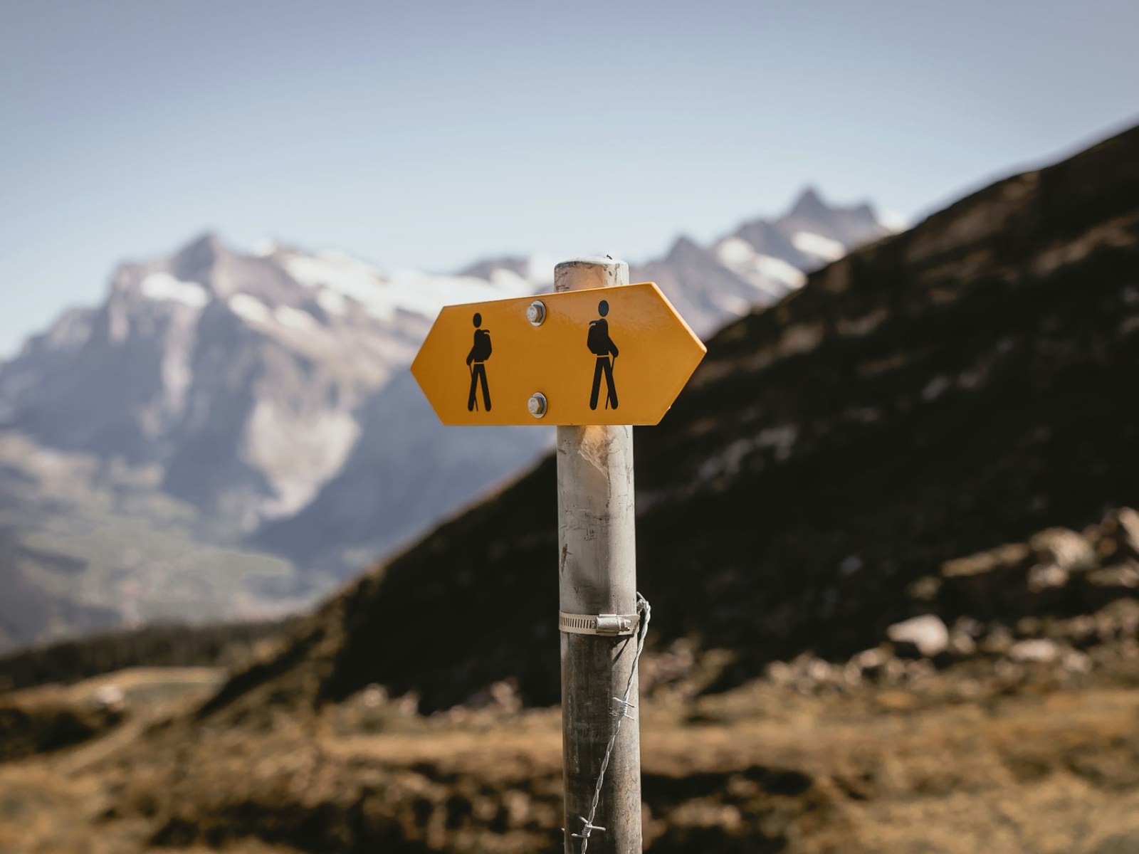
Signposts Include Actual Information
The yellow signs don't just point directions. They list intermediate destinations so you can track progress. They show elevation for each destination. Some include map references or coordinates.
This information density means a single signpost answers most navigation questions. You know where you are, where you're going, how far it is, how long it'll take, and how much you'll climb or descend.
The National Mapping Integration
Swiss trail markers correspond exactly to SwissMobility maps and apps. The route numbers on signs match the numbered routes on maps. The place names are identical. Times and distances align.
This integration means planning with a map and navigating on the ground use the same language. There's no translation needed between paper and reality. For those who prefer having experts handle navigation entirely, Switzerland hiking tours often provide guides familiar with this system who can focus on the landscape while managing route details.
Maintenance Happens Constantly
Trail markers don't fade into illegibility or disappear. Switzerland maintains the system actively throughout the hiking season. Damaged signs get replaced. Overgrown blazes get repainted. New markers appear if trail conditions change.
This ongoing maintenance costs money and effort. Switzerland considers it worthwhile infrastructure investment, like maintaining roads. The result is a system that actually works year after year.
Winter Considerations
Many trails close in winter or become dangerous. Swiss markers indicate winter status—some signs explicitly state "Winterwanderweg" for winter-approved routes. Others include warnings about seasonal dangers.
This prevents hikers from following summer routes into winter hazards. The system adapts to conditions rather than pretending all trails work year-round.
Emergency Information Built In
Many trail signs include coordinates or location codes useful for emergency services. If you need rescue, you can provide precise location information from the nearest marker. Helicopter rescue teams use these reference points routinely.
Some popular routes now include QR codes linking to real-time conditions, weather updates, or additional trail information. The system evolves without abandoning its fundamental reliability.
What This Means for Hiking
The Swiss marking system reduces navigation stress to near zero on established trails. You can focus on scenery, conversation, and physical experience rather than constantly checking maps or GPS. This mental freedom changes how hiking feels.
It also makes Switzerland accessible to less experienced hikers. Families, older adults, and people new to mountain hiking can navigate confidently. The infrastructure democratizes access without dumbing down the trails themselves.
The Downside Some People Notice
Experienced wilderness hikers sometimes find the system too managed. The constant markers eliminate any sense of remoteness or self-reliance. Every junction reminds you this is maintained infrastructure, not wilderness.
This is valid criticism. Switzerland trades wilderness character for accessibility and safety. Whether that's a good trade depends on what you value in hiking.
How Other Countries Compare
Austrian trails are well-marked but less standardized. Italian signage varies wildly by region. French trails can be excellent or terrible depending on local maintenance. American wilderness areas deliberately minimize markers to preserve wildness.
Switzerland's approach is uniquely systematic. The entire country follows identical standards, maintained to the same level, using the same symbology. This consistency is rare in mountain regions.
Using the System Effectively
Even with perfect markers, bring a map. Signs tell you where the trail goes, but maps show context—alternative routes, escape options, water sources, huts. The Swiss system works best when combined with basic map reading.
Pay attention to the time estimates rather than just distances. A 3-kilometer trail might take 2 hours if it climbs 500 meters. The signs account for this. Trust their timing more than your distance intuition.
The Cultural Element
The trail marking system reflects broader Swiss values—precision, maintenance, public infrastructure investment, and democratic access to mountains. It's not just about preventing lost hikers. It's about making the Alps accessible to everyone willing to walk.
This philosophy permeates Swiss hiking culture. The trails, the huts, the transport systems all work together as integrated infrastructure. The markers are just the most visible element of a comprehensive approach to mountain access.
Why It Actually Works
Switzerland's trail system succeeds because it's comprehensive, maintained, and standardized. Halfway measures don't work—a few good signs surrounded by faded markers just create confusion. Switzerland committed fully to doing it properly everywhere.
The result is a hiking experience where navigation becomes nearly automatic. You can get lost in Switzerland, but you'll really have to work at it.
© 2026 NatureWorldNews.com All rights reserved. Do not reproduce without permission.


