Meteorologists predicted that Tropical Storm Tammy could transform into a hurricane that could unleash rains in the Caribbean Islands.
They said that Tammy is slowing down as it approaches the Leeward Islands, noting that it is expected to bring tropical storm conditions and heavy rains in the island.
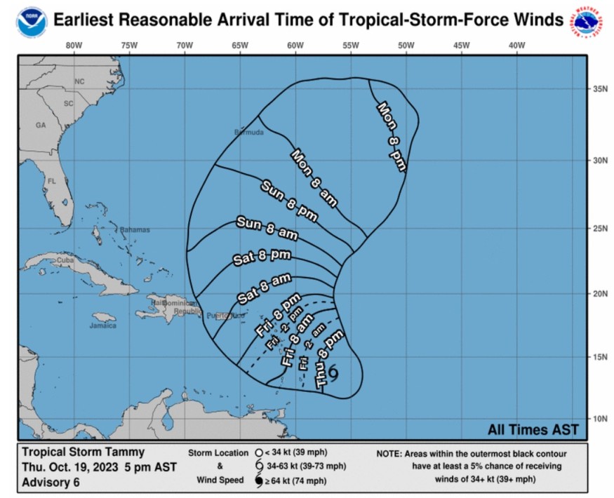
Tammy's Track
The National Hurricane Center said that at 800 PM AST (0000 UTC), the center of Tropical Storm Tammy was located near latitude 13.7 North, longitude 56.8 West.
Weather officials said that Tammy is moving toward the west-northwest near 10 mph (16 km/h).
A gradual turn to the northwest with some additional slowdown is forecast tonight into Friday, and this motion should continue through Saturday.
They said that a more northward motion is forecast to begin Saturday night or Sunday.
Meteorologists said that based on the forecast track, the center of Tammy will move near or over the Leeward Islands Friday and Saturday, and then it will track the north of the Leeward Islands Saturday night and Sunday.
Data obtained from both Air Force Reserve and NOAA reconnaissance aircraft indicate that the maximum sustained winds remain near 60 mph (95 km/h) with higher gusts.
Weather experts said that little change in strength is expected tonight, but gradual strengthening is expected to begin on Friday and continue into this weekend.
Tammy is forecasted to be at or near hurricane intensity when it moves near the Leeward Islands Friday night and Saturday.
Based on the forecast, tropical-storm-force winds extend outward up to 125 miles (205 km) primarily to the east of the center.
The latest minimum central pressure is estimated from reconnaissance aircraft data is 1001 mb (29.56 inches).
The government of Antigua has issued a tropical storm warning and hurricane watch for Anguilla.
Moreover, the government of St. Maarten has also raised a tropical storm warning for St. Maarten.
On the other hand, authorities in France also issued a tropical storm warning St. Martin and St. Barthelemy.
A hurricane watch means that hurricane conditions are possible within the watch area while a tropical storm warning means that tropical storm conditions are expected somewhere within the warning area within 36 hours.
Meanwhile, a tropical storm watch means that tropical storm conditions are possible within the watch area, generally within 48 hours.
Impacts Toward Leeward Islands
Tropical storm conditions are expected within the tropical storm warning area beginning Friday. Hurricane conditions are possible in portions of the Leeward Islands on Friday night and Saturday.
The weather system is also expected to produce storm total rainfall of three to six inches, with maximum amounts of 10 inches, across the Leeward and northern Windward Islands.
Wind gusts of 40 to 80 mph are also possible in the Leeward Islands. These may result in power outages and can uproot trees.
Furthermore, rainfall totals of one to two inches with maximum amounts of four inches are expected for the British and US Virgin Islands into eastern Puerto Rico. These rains may produce isolated flash and urban flooding, along with isolated mudslides in areas of higher terrain.
Tammy could also bring storm surges that may raise water levels by as much as one to three feet above normal tide levels near where the center of Tammy moves across the Leeward Islands.
The surf swells generated by Tammy are also seen to continue to affect portions of the Lesser Antilles during the next few days. These swells are likely to cause life-threatening surf and rip current conditions.
© 2026 NatureWorldNews.com All rights reserved. Do not reproduce without permission.


