Nigel, the sixth hurricane of the 2023 Atlantic hurricane season, could intensify into a major hurricane after developing a massive eye over the central Atlantic Ocean. Latest weather forecasts about Hurricane Nigel indicate that it may not affect mainland North America, including the United States.
However, the trajectory of the Atlantic hurricane shows it is moving towards Ireland and the United Kingdom by the end of the week.
Hurricane Nigel developed as a tropical storm in the Atlantic Ocean last week, where it was initially detected between West Africa and the Leeward Islands, according to a forecast by the National Hurricane Center (NHC) that was also covered by Nature World News.
During its early phase, the NHC forecasted that the former Tropical Storm Nigel could be the next Atlantic Hurricane. Furthermore, initial projections showed Nigel could impact Bermuda. However, the trajectory of this year's sixth Atlantic hurricane changed as it hovered the central Atlantic in recent days.
Hurricane Nigel Landfall
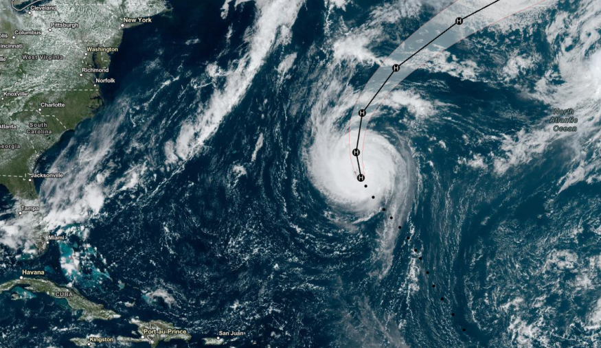
Although current forecasts show Hurricane Nigel will not make any landfalls yet, meteorologists are still monitoring its journey in the open waters of the central Atlantic. According to AccuWeather hurricane experts, Nigel is "becoming a rare type of hurricane."
Currently, Nigel is traversing the Atlantic 690 miles east-southeast of Bermuda with winds of 85 miles per hour, which it became a Category 1 storm as of Tuesday morning, September 19. It is moving in a northwestward pattern at a speed of 13 miles per hour, according to AccuWeather.
AccuWeather's Tropical Meteorologist Alex DaSilva explains that Nigel is transforming into an annular hurricane, which means it is a hurricane with a large eye that resembles the appearance of a truck tire or doughnut.
Annular Hurricanes
Based on a study published in the journal American Meteorological Society, annular hurricanes or AHs are rare weather events that occur in less than 4% of all hurricane phenomenon, making conventional statistical identification algorithms to be impractical.
According to the study's researchers, annular hurricanes have been shown in previous reports to be significantly stronger, to have longer duration, and weaken more slowly than average tropical hurricanes or cyclones.
In the case of Hurricane Nigel, its potential characteristic to become an annular hurricane means it can sustain itself for a prolonged period over the Atlantic.
NHC Forecast on Nigel
According to the NHC, Hurricane Nigel has a current maximum sustained wind of 90 miles per hour and moving in a north-westward pattern at 16 miles per hour, which is higher than the AccuWeather forecast.
The NHC projects that Nigel will continue to navigate the central Atlantic until Friday, September 22. By Saturday, September 23, it will reach the western waters near Ireland and Northern Ireland.
Currently, the long-term impact of Hurricane Nigel is still unclear. However, there is a risk of coastal flooding due to hurricane-force winds in Atlantic coastal areas.
© 2026 NatureWorldNews.com All rights reserved. Do not reproduce without permission.


