Meteorologists said that Nigel has strengthened into a hurricane, making it the 5th in the 2023 Atlantic hurricane season.
According to weather experts, Nigel will most likely reach major hurricane strength.
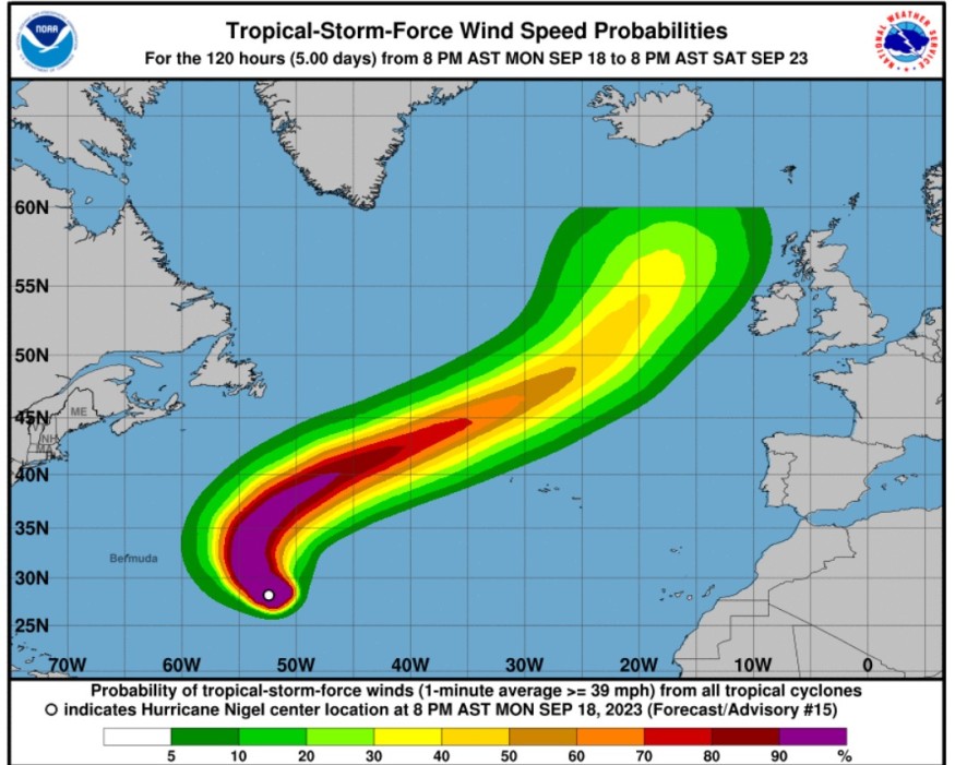
Nigel's track
The National Hurricane Center and Central Pacific Hurricane Center said that at 1100 PM AST (0300 UTC), the center of Hurricane Nigel was spotted near latitude 28.6 North, longitude 52.7 West.
Meteorologists said that Nigel is tracking the direction toward the northwest near 12 mph (19 km/h), and this general motion is expected to continue through Tuesday.
It is also seen to turn northward late Tuesday, and then accelerate northeastward through the rest of the week.
Weather experts said that Nigel's maximum sustained winds have increased to near 85 mph (140 km/h) with higher gusts. Furthermore, it is expected that there would be additional strengthening during the next day or so.
On the other hand, Nigel could gradually weaken beginning late Wednesday.
The hurricane-force winds extend outward up to 30 miles (45 km) from the center and tropical-storm-force winds extend outward up to 160 miles (260 km).
Meanwhile, the estimated minimum central pressure is 979 mb (28.91 inches).
The weather forecast noted that Nigel continues to move northwestward (310 degrees) at about 10 kt.
Weather experts explained that the hurricane should continue on that general heading and speed through midday Tuesday. However, as it nears the western extent of the ridge, Nigel is predicted to turn northwestward and northward shortly thereafter.
In the next 48 hours, an approaching mid- to upper-level trough is also forecasted to cause Nigel to accelerate northeastward over the central and northeastern Atlantic through the remainder of the forecast period.
They said that track guidance remains tightly clustered, with the primary differences being how much Nigel accelerates northeastward later in the period.
When it comes to the surf, the swells generated by Nigel are expected to reach Bermuda on Tuesday. These swells are likely to cause life-threatening surf and rip current conditions.
So far, there are no coastal watches or warnings in effect.
Further strengthening
Meteorologists warned that there is a high risk for additional strengthening of the weather system as it moves across the central Atlantic into the early week.
It is likely that Nigel would reach the major hurricane strength, according to weather experts. A major hurricane is defined as a Category 3 or stronger storm based on the Saffir-Simpson Hurricane Wind Scale (SSHWS).
This means that it would pack winds of at least 111 mph.
They said that the factors which could drive the potential for strengthening are the very high ocean water temperatures and light winds higher up in the atmosphere, known as wind shear to meteorologists.
Beyond Bermuda, it is possible that Nigel will survive as a tropical wind and rainstorm and will also bring impacts to the United Kingdom this weekend.
"At the very least, Nigel will create a zone of rough seas and squalls as it churns northeastward over the North Atlantic and will remain a concern for shipping," AccuWeather Senior Meteorologist Alex Sosnowski said.
Related Article : Developing Tropical Storm Nigel Could Become the Next Atlantic Hurricane, Follow the Track of Hurricane Lee
Related Video:
© 2026 NatureWorldNews.com All rights reserved. Do not reproduce without permission.


