Weather forecasters said that Hurricane Lee is expected to create some autumn conditions in the eastern portion of the United States.
Based on the weather forecast, the temperature in New York could prompt residents and tourists to wear a jacket in the evening as well as during early morning hours through the coming weekend.
The breeze generated by Hurricane Lee is seen to add to the autumn-style coolness through Saturday. Meteorologists said that the daytime highs in the city through the weekend will be in the 70s.
Meanwhile, Philadelphia and Washington, D.C. would feel less in terms of the breeze during the weekend.
On the other hand, areas in the farther south would feel the same level of coolness, including in cities, such as Charlotte and Atlanta.
Meteorologists also said that the temperatures in most of the areas of Virginia, the Carolinas and northern Georgia would be in the low to mid-80s over the weekend.
Read Also : Hurricane Lee: Landfall Forecasted In Maine, Canadian Maritimes As It Makes Critical Turn In Atlantic
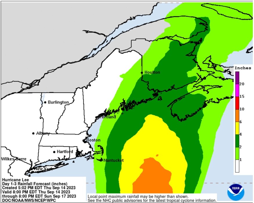
Lee's forecasted track
The National Hurricane Center and Central Pacific Hurricane Center said that at 800 PM AST (0000 UTC), the center of Hurricane Lee was spotted near latitude 32.1 North, longitude 68.0 West.
Based on the forecast, Lee is tracking the direction towards the north near 15 mph (24 km/h) and this general motion with a significant increase in forward speed is expected through Saturday.
Meanwhile, a turn towards the north-northeast and then northeast has been forecasted Saturday night and Sunday.
Weather experts said that the center of Lee would continue to pass west of Bermuda through this evening and approach the coast of New England and Atlantic Canada either Friday or Saturday.
Lee will then move across Atlantic Canada on Saturday night and Sunday.
It is packing maximum sustained winds near 85 mph (140 km/h) with higher gusts. Meteorologists took note that a little change in Lee's strength could be observed on Friday afternoon.
Furthermore, some gradual weakening is forecasted on Friday night and Saturday.
Despite its weakening, Lee is expected to remain large and dangerous for the next couple of days as it is still categorized as a very large hurricane.
Hurricane-force winds extend outward up to 105 miles (165 km) from the center and tropical-storm-force winds extend outward up to 345 miles (555 km).
So far, a sustained wind of 43 mph (69 km/h) was recently reported at the L.F. Wade International Airport in Bermuda.
Dangerous surfs, rip currents
Weather experts said that dangerous surfs and rip currents have started to affect the eastern coast of US.
At present, a hurricane watch is in effect over Stonington, Maine to the US/Canada border, New Brunswick from the US/Canada border to Point Lepreau, including Grand Manan Island, and Nova Scotia from Digby to Medway Harbour.
Meanwhile, a tropical storm warning has been raised over Bermuda, Westport Massachusetts northward to the US/Canada border, Martha's Vineyard, Nantucket.
On the other hand, a tropical storm watch has been placed issued in New Brunswick from north of Point Lepreau to Fort Lawrence, Nova Scotia west coast from north of Digby to Fort Lawrence, and Nova Scotia southeast coast from north of Medway Harbour to Point Tupper.
The combination of storm surge and tide will cause normally dry areas near the coast to be flooded by rising waters as it moves inland from the shoreline.
Officials warned that the water could reach above ground somewhere in the indicated areas if the peak surge occurs at the time of a high tide.
Related Article : Hurricane Lee: Nova Scotia Warned Over Powerful Winds, Floods; Impact Still Seen In Atlantic Canada
Related Video:
© 2026 NatureWorldNews.com All rights reserved. Do not reproduce without permission.


