Tropical Storm Roslyn is expected to hit the western coast of Mexico, causing strong winds, heavy rains, and flooding rainfall. Forecasts said that Roslyn could reach hurricane level.
The National Hurricane Center (NHC) posted that Tropical Storm Roslyn could bring hurricane conditions to the west and central Mexico. Residents in the said areas should stay updated with the storm's development.
NHC said that the storm continued to move west-northwestward around seven mph or 11km/h. The National Hurricane Center located Tropical Storm Roslyn over the south of Manzanillo, Mexico (About 190 miles or 305 km)
The advisory said that Tropical Storm Roslyn maintained a near 65 maximum winds up to 100 km/h with recorded higher gusts, noting that the storm could unleash tropical storm-force winds.
Roselyn Impact
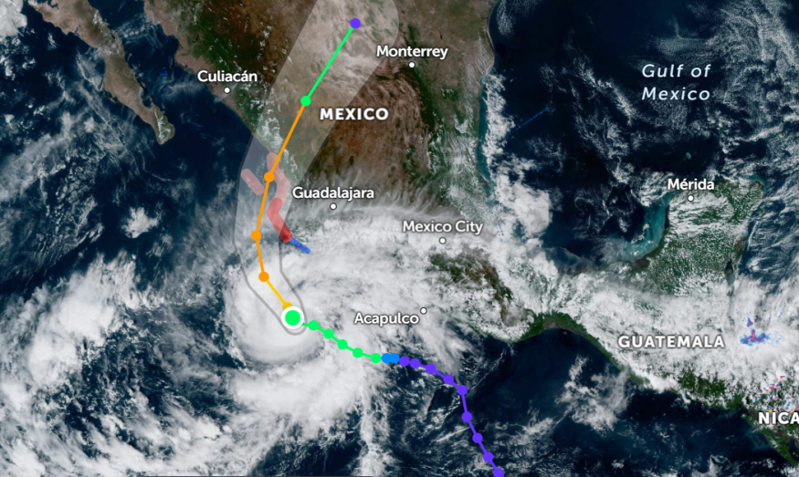
Moreover, the report said that the tropical storm could become a hurricane, reaching west-central Mexico on Sunday.
Meanwhile, Tropical Storm Roslyn is expected to strengthen the next day rapidly. The tropical storm would make landfall on the coastline of west-central Mexico on Saturday night or Sunday.
According to the National Hurricane Center's advisory, the tropical storm could cause hurricane conditions in the watch areas on Saturday night or early Sunday. Meanwhile, tropical storm conditions could be seen in the tropical warning areas starting Saturday.
- Rainfall warnings could occur in southwestern and west central Mexico, which could cause flash flooding and landslides. Meanwhile, the rainfall would reach up to one to three inches in Guerrero and Michoacan. Colima and Jalisco could expect up to two inches to four inches. At the same time, portions of Nayarit, Islas Marias, and Southeastern Sinaloa could have four to 6 inches of rainfall (Maximum up to eight inches).
- The portions where Tropical Storm Roslyn would make landfall could experience dangerous storm surges that could result in coastal flooding up to the east portion.
- Areas on the coast of southwestern Mexico, west-central Mexico, Baja California Peninsula's southern portion should be wary of strong waves and life-threatening surf.
Meanwhile, the National Hurricane Center announced on October 21, 2022 that they located a non-tropical low-pressure area in the East of Bermuda. However, the report said it had only a 20% low chance of forming.
Also Read: Return of Summerlike Warmth Could Unleash in Midwest This Weekend
Moreover, the AccuWeather latest report on October 21, 2022, showed that Tropical Storm Roslyn's impact through Monday could cause locally strong winds, flooding rainfall, mudslides, power outages, and rough surf.
Roselyn Preparations
Based on the weather updates, Tropical Storm Roselyn is expected to pound western-central Mexico, causing heavy rains and strong winds. Tropical Storm Roselyn could unleash hurricane conditions in the said areas. As a result, early preparations for tropical storm is important for affected residents.
- Weather reports emphasized the significance of staying updated with the weather news, from Tropical Storm Warning and Watches.
- Ensure that mobile devices are fully charged in a power outage or emergency. Mobile phones can provide a flashlight and immediately contact authorities or family members for storm updates.
- Check your roof and windows for potential damages due to Tropical Storm Roselyn. You can keep your belongings elevated near the coast or flood-prone areas. Keep a bag for evacuation.
- People near the coasts should stay on alert for rising sea levels. Immediately evacuation for potential and rapid sea rise.
- Tropical Roslyn is said to unleash heavy rains that could inundate major roadways and result in zero visibility. It is best to cancel your trips after the tropical storm abates.
Related Article : What to Expect this Coming Winter in Parts of the United States
For more similar, don't forget to follow Nature World News.
© 2026 NatureWorldNews.com All rights reserved. Do not reproduce without permission.


