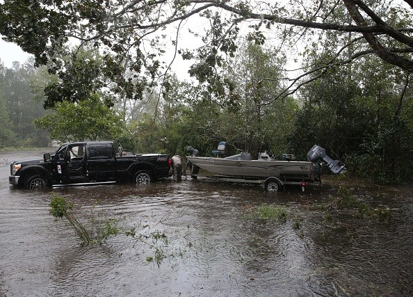
Although Houston's hurricane season begins next week, officials began monitoring a low-pressure region in the Gulf of Mexico on Sunday.
It was the first national forecast released by the National Hurricane Center for 2022.
Hurricane in Houston this week
ALEX EDELMAN/AFP via Getty Images
The low-pressure system has now moved inland and was over south-central Alabama on Monday morning.
It is forecasted to continue moving overland on Monday but will not develop into a tropical storm.
However, significant rains are expected in certain towns across the southeastern United States during the next day or so.
The hurricane season begins on June 1, and the National Oceanic and Atmospheric Administration will announce its forecast for the 2022 Atlantic hurricane season on Tuesday.
According to NOAA, 14 to 21 storms will become large enough to be named. Forecasters predicted six to 10 hurricanes, three to six of which will have sustained winds of more than 110 miles per hour, as per Houston Public Media.
If the forecast is true, this will be the eighth year in a row with more storms than usual, by far the longest stretch in recorded history.
Although storms can form outside of these dates, the Atlantic hurricane season officially begins on June 1 and finishes on November 30.
NOAA revised its definition of a typical hurricane season last year to reflect the new normal of climate change.
It now considers "above-average" hurricane seasons to include more than 14 named tropical storms, rather than 12.
To put things in perspective, the record-breaking 2020 hurricane season generated 30 named storms. Not all hurricanes make landfall, but when they do, the devastation may be massive.
Storms that originate over the Atlantic Ocean and proceed toward the East Coast and Gulf of Mexico endanger hundreds of millions of people in the United States.
Many people live far from where hurricanes usually make landfall, and as a result, they may have a false feeling of security.
This spring, an unusually warm ocean current is also pushing towards the Gulf of Mexico, threatening to unleash a big and deep blob of hot water during hurricane season.
This would produce a dangerous hurricane breeding ground, increasing the likelihood of a big storm hitting Mexico or the United States. The Gulf Coast.
Tuesday Evening Outlook:
The rest of the day will be gloomy and overcast, with temperatures in the 70s.
Additional storms are likely later today, although they will be scattered.
The next series of storms is expected to arrive tonight, as per Click2Houston.
Forecast for Wednesday:
A cold front is expected to arrive Wednesday morning. Storms may have enough force to cause severe weather and street flooding.
As the cold front approaches, damaging winds, a tornado or two, and hail are probable.
Storms will move in quickly, bringing strong to destructive gusts of 40mph or more, as well as heavy rain along the line.
Total Rainfall:
The cold front will bring heavy rain on Wednesday morning. Most will get one to two inches of rain, but some isolated locations may get more, resulting in street flooding.
However, because to the speed with which the cold front is moving, we do not anticipate significant flooding.