A dose of winter weather and high winds is forecast to travel from the northern Rockies to the Upper Midwest, putting residents in the north-central United States in for another nasty week.
Early in the week, the storm is forecast to hit the West Coast first, bringing rain and mountain snow to parts of the Northwest and British Columbia in western Canada.
According to Meteorologist Joseph Bauer, a region of high pressure rising off the coast of California will guide this from the Northwest towards the northern Plains.
Pressure Difference
The significant pressure differences between the two features will also aid in forming a powerful storm with two primary threats: snow and high winds.
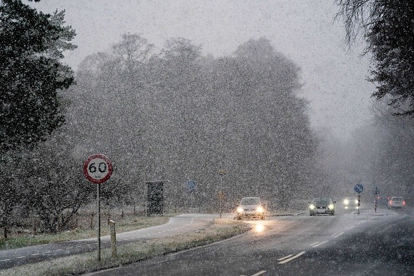
From early Tuesday through Wednesday night, snow from the northern Rockies is expected to move eastward across the northern Plains and Upper Midwest. The largest accumulations are anticipated in Montana and Idaho, Wyoming and northern Colorado, and along the US-Canada border.
Cold air in situ throughout the Arrowhead of Minnesota might force precipitation to retain snow in that location throughout the event, Bauer stated. General accumulations of 1 to 3 inches are probable over North Dakota and northern Minnesota by Wednesday morning.
As the storm advances eastward through Wednesday, rain showers in places like Madison, Wisconsin, and Minneapolis might turn to wet snowflakes. Temperatures in this area may still be cold enough for snow to stay on the ground. If snow can accumulate, isolated, tricky situations may occur.
Additional dangers are forecast throughout the storm, including snowfall and high gusts.
"An area of disruptive wind is forecast Tuesday throughout the northern and central Rocky Front, with wind gusts of over 60 mph possible, especially in prone regions of southeast Wyoming and north-central Colorado," Bauer said.
Along the eastern slopes of the Rocky Mountains, wind gusts of up to 80 miles per hour are possible.
Trajectory
According to AccuWeather meteorologists, stormy winds will accompany the storm into the Plains and Midwest until the middle of the week. Threats toppled trees and powerlines, isolated damage, and power outages will accompany them.
According to Bauer, gusty northerly winds and snow showers could cause isolated areas of increased accumulation, limited visibility, and challenging navigation for travelers traveling on Interstate 90 and 94 across the Dakotas and Upper Midwest on Wednesday.
A surge of frigid Canadian air is predicted to drop southward over the central United States behind the storm, adding to the storm's wintry feel.
After a high in the upper 60s on Monday, afternoon temperatures in Rapid City, South Dakota, are expected to struggle to reach 40 degrees by Wednesday, about 15 degrees below typical for early April. The coldest air will continue to move further south and east throughout the week, bringing comparable temperature decreases to locations like St. Louis and Kansas City, Missouri.
The gusty winds will make it seem even colder than the temperature reading, with temperatures in the teens and 20s F from Colorado and Wyoming to central Minnesota and Iowa on Wednesday morning.
Duration
The frost is expected to last through Thursday for many in the Midwest, threatening a winter-like start to the MLB baseball season. Players and fans attending the Minnesota Twins, St. Louis Cardinals, and Chicago Cubs' home openings may be met by weather more akin to early March.
As the coldest air moves into the Tennessee Valley and most of the southeastern United States, temperatures are expected to rise in the Northern Plains and Midwest by the weekend.
Related Article : Drought-Stricken American Southwest Finally Got Much Needed Rain
For more news about similar news, don't forget to follow Nature World News!
© 2026 NatureWorldNews.com All rights reserved. Do not reproduce without permission.


