Temperatures will be on the colder side with highs in the upper 20s. It may feel colder due to a steady breeze from the north. Clear skies remain Thursday night with lows dipping back down into the teens said Storm Center 7 Meteorologist Jesse Maag.
In the wake of the departing low, cold north winds flowing down Lake Michigan will likely generate some Lake Effect snowfall for southeast Wisconsin, especially Milwaukee, Racine and Kenosha counties. This would mainly be for late Friday night into Saturday night.
The image below shows a winter storm expected to track from Oklahoma to the Mid Atlantic this weekend. Normally, for our area to see a major winter storm, we would like to see the center of an intense low-pressure system move across northeast Illinois/Indiana. This one is moving much farther south, from Arkansas to the Mid-Atlantic states. So, we're not expected a major, widespread winter storm for southern Wisconsin.
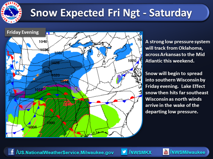
Due to the Lake Effect contribution, far southeast Wisconsin will have the best chance of seeing accumulating snow due to the Lake Effect potential. Amounts farther inland will be lower. Given how far south the center of the low is tracking, confidence is not very high right now on exact snow amounts, so expect many adjustments as we approach the start of the snow at the end of the work week. FRIDAY: It will be another very cold morning for the end of the workweek with temperatures rising from the teens. Skies will be mostly sunny with a high a bit closer to normal in the lower 30s. Winds relax for Friday.
Forecast
The following are the perceived forecast over the weekend until the first days of the following week:
SATURDAY: Clouds increase on Saturday with highs in the middle 30s. The chance of rain/snow arriving late day into the night. Accumulating snow is becoming likely.
SUNDAY: Ending the weekend we will see a mix of rain and snow, but we likely switch to all rain by midday. Windy with a high near 40.
MONDAY: The workweek will start mostly cloudy, windy, and cold with some scattered light snow showers. Highs in the lower to middle 30s.
Related News:Southern States Snow: Almost 5-Inch Ice Covered Texas, Mississippi, and Loussiana
Winter Storm Preparedness
It won't do anyone harm to be a little more careful and prepared during the winter season than usual. The following are great ways to prepare for possible snowstorms or blizzards:
- Prevent pipes from freezing;
- Insulate walls;
- Clear chimneys, vents, and other exhaust ports;
- Maintain a sound heating system;
- Terminate rodents and other pests in the house;
- Stocking up on food and rations;
- Have spare utility supplies in case of emergency;
- Stock up on de-icing products and heavy-duty anti-snow types of equipment;
- Have winter tires;
- Prepare for possible power outages;
- Prepare an emergency kit; and
- Plan winter route in case of necessary travels.
During these times, it would be best to stay inside one's home's safety rather than risk getting in a road accident.
ALSO READ: Snowmageddon: Polar Vortex Split May Result to Weeks of Intense Winter
For more environmental new, don't forget to follow Nature World News!
© 2026 NatureWorldNews.com All rights reserved. Do not reproduce without permission.


