Volcano eruptions command attention as forces of raw geological power, with volcano eruption science unlocking secrets of molten chaos beneath our feet. Insights from eruption cycles and vigilant volcano monitoring now sharpen focus on lava flow safety, helping communities brace for the unpredictable.
Unraveling Volcano Eruption Science Basics
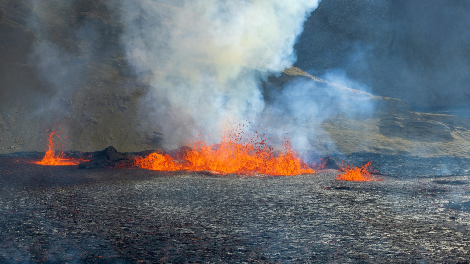
Volcano eruption science hinges on the interplay of magma composition, pressure, and gas content deep within Earth's crust. Magma, a mix of molten rock, crystals, and dissolved gases, rises when buoyant forces overcome overlying rock. Silicate-rich magma tends toward explosive outbursts, forming stratovolcanoes like Mount St. Helens, while fluid basaltic types produce gentler Hawaiian-style flows.
This field draws from decades of observation. For instance, geologists study how viscosity controls flow: thicker magmas trap gases, building pressure for Plinian eruptions that loft ash 30 kilometers high. Dissolved water and carbon dioxide act as triggers, expanding into bubbles during decompression. Recent models simulate these dynamics, predicting blast radii based on vent geometry and ascent rates.
Key elements in volcano eruption science include:
- Magma chambers: Reservoirs 2-15 kilometers deep where differentiation occurs, concentrating volatiles.
- Conduit dynamics: Narrow pipes channeling magma, prone to blockages from cooling edges.
- Effusive vs. explosive: Low-silica lavas (under 52% SiO2) flow freely; high-silica versions shatter violently.
Understanding these mechanics aids risk zoning, as seen in studies from Lumen Learning's Earth Scienceresources, which detail eruption mechanics through layered diagrams.
Advances in Volcano Monitoring Techniques
Volcano monitoring forms the frontline defense, blending seismic, geodetic, and geochemical tools to detect unrest before it escalates. Seismometers capture micro-quakes signaling fluid migration, while tiltmeters measure subtle ground swelling from inflating chambers. Gas spectrometers track sulfur dioxide plumes, a hallmark of fresh magma input.
Networks like the USGS Volcano Hazards Program operate 24/7, integrating satellite InSAR for millimeter-scale deformation over vast areas. Drones now sample plumes directly, dodging ash clouds to measure ratios of CO2 to SO2—elevated levels hint at shallow degassing. Infrasound arrays pick up low-frequency rumbles from distant vents, extending detection radii.
Effective volcano monitoring follows these steps:
- Baseline establishment: Years of quiet-period data set norms for quakes, emissions, and tilt.
- Anomaly detection: Swarm activity or thermal spikes trigger Level Yellow alerts.
- Forecasting integration: Probabilistic models weigh precursors against historical patterns.
- Public relay: Apps and sirens disseminate updates, calibrated to eruption styles.
GeoNet's monitoring protocols, outlined in their operational guides, exemplify real-world application, saving lives through timely evacuations. These systems have shortened warning times from months to days at active sites like Iceland's Reykjanes.
Patterns Within Eruption Cycles
Eruption cycles reveal volcanoes' rhythmic behavior, from repose spanning centuries to clustered outbursts over decades. Short-term cycles at basaltic shields like Kilauea follow inflation-deflation episodes, tied to magma recharge every few years. Explosive andesitic systems exhibit repose-eruption-repose loops, influenced by crustal stress and recharge rates.
Longer cycles link to climate shifts. Milankovitch orbital variations drive glacial loading-unloading every 10,000-600,000 years, stressing magma systems as ice sheets wane. Frontiers in Earth Science research highlights how such forcings amplified activity during interglacials, imprinting lava records with periodic spikes.
Typical phases in eruption cycles:
- Pre-eruptive unrest: Swarms and deformation build over weeks.
- Climactic phase: Peak effusion or explosion, lasting hours to months.
- Waning: Degassing tapers, fissures seal.
- Post-eruptive calm: Monitoring intensifies for aftershocks.
These patterns guide long-term planning. Hazard maps overlay cycle data with demographics, prioritizing reinforced infrastructure in high-recurrence zones.
Essential Lava Flow Safety Measures
Lava flow safety demands proactive zoning, as 'a'a and pahoehoe advance at 10-50 km/h on steep terrain, incinerating everything downslope. Hazard maps delineate probabilistic paths based on topography and past flows, directing development away from channels. Evacuation routes prioritize uphill, cross-slope paths to outpace slow-moving fronts.
Preparation mirrors wildfire readiness: clear vegetation 30 meters out, stock non-combustibles like metal roofs. Wetting ground offers fleeting resistance via steam barriers, though diversions rarely halt determined flows. Personal kits include leather gloves, respirators for vog (volcanic smog), and satellite phones for remote areas.
Core lava flow safety strategies:
- Zone awareness: Live outside red zones; check USGS lahar and flow forecasts.
- Home hardening: Install heat-reflective shutters, earthen berms.
- Evacuation drills: Practice night routes, vehicle loads under 10 minutes.
- Community hubs: Stockpile generators, medical caches at elevation.
Batten Home Security's escape plans stress these layered tactics, proven in Hawaii's Puna district during prolonged 2018 flows. Post-event reviews refine protocols, emphasizing pets and elders in drills.
Signs of Imminent Eruptions to Watch
Precursors blend into clear signals: accelerating quakes, summit inflation exceeding 10 cm, and gas fluxes doubling baselines. Thermal anomalies via MODIS satellites glow before fissures crack, while fumaroles intensify with acidic steam. Lahar risks a spike from crater lake heating.
Cross-verification sharpens accuracy. A USGS-style alert escalates from Green (normal) to Orange when multiple lines converge, prompting 50-100 km buffers for aviation.
Putting Monitoring and Safety into Action
Communities thrive by weaving volcano eruption science with daily vigilance—eruption cycles forecast renewal, volcano monitoring delivers nowcasts, and lava flow safety protocols turn warnings into survival. Sites like Hawaii Volcanoes National Park embody this, blending education with resilient design. Proactive steps, from app alerts to barrier walls, bridge knowledge gaps against nature's displays.
Frequently Asked Questions
1. What Causes a Volcano to Erupt?
Volcano eruption science explains eruptions through magma pressure buildup. Gases like water vapor and CO2 dissolve in molten rock deep underground, then expand violently as magma nears the surface. Silicate-rich magma creates explosive events, while basaltic types yield fluid flows.
2. How Do Scientists Predict Volcanic Eruptions?
Volcano monitoring relies on seismometers for quake swarms, gas sensors for SO2 spikes, and GPS for ground deformation. Precursors like harmonic tremors signal magma movement days ahead. Integrated observatories issue probabilistic alerts based on historical eruption cycles.
3. What Are Signs of an Imminent Eruption?
Watch for swelling summits, increased earthquakes, thermal hot spots, and rising volcanic gases. Fumaroles emit more steam, and infrasound detects low rumbles. These align with eruption cycles' pre-eruptive unrest phase.
© 2026 NatureWorldNews.com All rights reserved. Do not reproduce without permission.


