After a hazardous heat concern, Texas residents and commuters can experience the return of rainy conditions. According to a weather report on May 15, potential flash floods and river flooding can occur this weekend.
The main concerns are the impacts on flood-prone or low-lying areas in parts of Texas, as a severe weather outlook continues to affect portions of the south-central U.S.
When commutes are not essential or could be rescheduled, it is best to stay at home or monitor the latest weather information in the southern U.S.
Texas Weather Outlook: What Can People Expect This Weekend?
As outdoor enthusiasts gear up for the weekend, it is advisable to consider the weather this late week due to potential flooding rainfall and flooded roads.
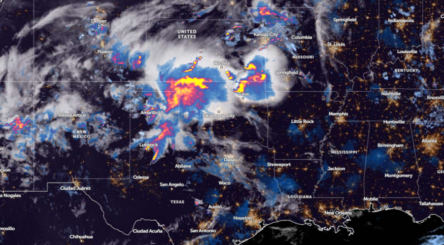
In a report by the National Weather Service (NWS) for May 16, the advisory warns of a moderate risk of excessive rainfall in parts of Texas and Louisiana. Flood Watches are already issued in affected areas.
In addition, a risk of scattered severe thunderstorms could unload this week, packed with very large hail, tornadoes, and damaging winds.
In a similar report, an NWS Weather Prediction Concerned raised concerns about a heavy rainfall threat in the Southeast. The weather information shows that portions of Texas could expect three to five inches of rainfall. Due to the rainy potential, houses in flood-prone areas are vulnerable to flooding.
The return of a wetter outlook is expected to spread over parts of Florida this weekend. People traveling from Texas to Florida on Interstate 10 and Interstate 20 corridors could experience hazardous travel due to flooding concerns.
On Thursday, showers and thunderstorms are forecast in the following areas:
- Lubbock
- Oklahoma City
- Wichita
- Austin
- Dallas
- Houston
- San Antonio
- Corpus Christi
For Houston residents, the advisory advises residents to watch out for another round of locally heavy rain and severe storms this late week. Residents north of Interstate 10 should stay alert for poor weather outlook. Additionally, there is a Flood Watch due to excessive rainfall potential.
From Thursday to Saturday, a rainy outlook is expected to continue. Areas at risk of rounds of rain are Wichita Falls, Dallas, Austin, Houston, New Orleans, Mobile, Jackson, Birmingham, Atlanta, and Tallahassee.
River and stream flooding are also a primary concern in Houston, Mobile, Montgomery, Jackson, and Alexandria. Communities near rivers should be alert for evacuations.
Weather in other parts of the U.S: Where Will Stormy Outlook Hit?
In other parts of the U.S., an NWS advisory shows that unsettled weather and stormy outlook could hit central and eastern portions of the Lower 48.
In Coastal New England and Eastern Long Island, there is a risk of rainfall, including in the Northeast.
For more similar stories, don't forget to follow Nature World News.
© 2026 NatureWorldNews.com All rights reserved. Do not reproduce without permission.


