The latest weather report warns that potentially isolated thunderstorms and strong wind gusts will be likely this week in parts of Colorado and Utah.
People with travel plans should stay updated with the latest weather reports, particularly in Colorado. Motorists should watch out for slower commutes, and changing weather conditions this weekend.
In the Cascades and Northwestern US, residents should keep alert for potential wet weather outlook. Meanwhile, Cascades can anticipate possible wet snow in the higher elevation areas. Freezing conditions are likely from the Midwest to southern New England.
Weather Outlook in Colorado and Utah this week
Meanwhile, the NWS Hazardous Weather Outlook shows that a cold front could occur in eastern Utah and Western Colorado. Snow will likely be present in the highest elevations in the said areas.
However, commuters should monitor for possible showers and thunderstorms. The forecast monitors the next system on Friday, bringing stormy conditions. Widespread precipitation is likely, with a chance of accumulating snowfall.
In parts of Colorado, wind gusts can reach up to 55 mph and around 60 mph on Highway 50. Possible fire danger can occur in southern Colorado.
Meanwhile, there is a risk of strong to severe storms in the eastern Plains, bringing potential hail and strong wind gusts. Next week, cooler temperatures and heavy mountain snow can continue in Colorado.
In the Sterling to Akron areas, challenging weather conditions are likely, including in Fort Morgan and eastern Weld County. The severe thunderstorm ppotential can unleash tornado risk.
In northeast and north-central Colorado, the Interstate 25 corridor can experience scattered rain showers. In the mountainous areas, two to five inches of snow will be likely on Friday. Commuters should watch out for slushy or snow-covered roads.
In Western and Central Wyoming, the latest advisory reports that rainy conditions and a few thunderstorms can occur this week. Until the weekends, a wet pattern will continue, causing slower commutes in the said areas.
Severe Weather Outbreak This Week
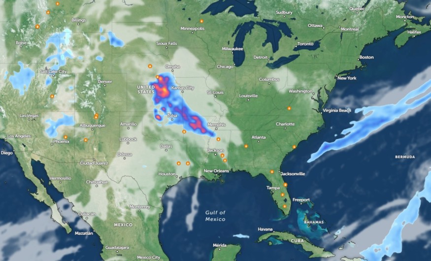
The latest weather report reveals a severe weather outbreak could unload in the Central US this week, bringing potential threats to commuters. Potential damaging winds, hail, and isolated tornadoes are all likely.
A challenging weather outlook is likely in the following areas:
- Scottsbluff
- Sioux Falls
- Des Moines
- Kansas City
- St. Louis
- Chicago
- Green Bay
- Little Rock
- Oklahoma City
- Dallas
- Austin
- Lubbock
On the weekend, the severe weather threats can unload in Marquette, Gren Bay, Rochester, Madison, Omaha, and Des Moines.
Meanwhile, NWS Des Moines reports that strong to severe storms will be likely in central Iowa. The main concerns are tornadoes and hail.
Meanwhile, The NWS Weather Prediction Center warns of excessive rainfall in the Arklatex region, threatening flash floods and a wet weather outlook.
For more similar stories, don't forget to follow Nature World News
© 2026 NatureWorldNews.com All rights reserved. Do not reproduce without permission.


