Meteorologists warned against high risk of thunderstorms and tornadoes over Mississippi Valley.
A strengthening storm fueled by the moisture that is from the Gulf of Mexico is expected to ignite a significant round of severe weather, which will put lives and property at risk.
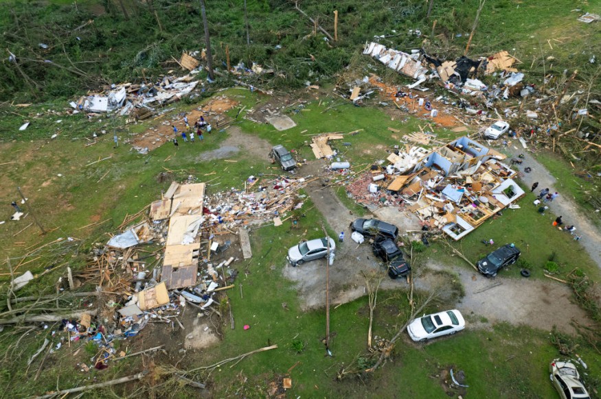
Violent Thunderstorms, Multiple Tornadoes
Weather experts noted that it has been many weeks since there was a significant outbreak of severe weather in the United States.
They warned that there is a high chance that violent thunderstorms with multiple tornadoes would occur over the lower part of the Mississippi Valley.
Meanwhile, some of the severe weather and tornado-producing storms will linger well after dark, which will add to the danger that the system will bring.
These storms, energized by the stream of water-laden and warm air from the Gulf of Mexico, will become severe.
Weather forecasters said that downpours, damaging winds and isolated tornadoes will be the biggest threat through the afternoon and evening hours from eastern Texas eastward into southern Arkansas, Louisiana Mississippi and western Alabama.
To recall, officials said that the last significant severe weather outbreak in the U.S. was centered on the Great Plains on October 3 to 4, when at least 175 storm reports were filed including eight tornadoes.
Furthermore, severe thunderstorms have not occurred since September 26 in Louisiana and way back on September 7 in Mississippi -- both states are in the thick of Monday's severe weather setup.
According to weather experts, thunderstorms began to erupt during the midday hours on Monday and a number of these thunderstorms had already become severe in the afternoon, bringing high winds, hail and torrential downpours in the zone from northeastern Texas to western and central Mississippi to southern Arkansas.
Meanwhile, some of the strongest storms have started to rotate and it is within these rotating thunderstorms that tornadoes are likely to develop into the evening hours.
Meteorologists said that there are likely to be multiple tornadoes on the ground into Monday night from northeastern Texas to the lower part of the Mississippi Valley.
They have outlined a high-risk area from the northeastern corner of Texas through much of northern Louisiana as well as into central Mississippi.
Officials have warned that the most significant risk of tornadoes will occur within that corridor.
Still, tornadoes will be possible to the north of this zone to central Arkansas and southwestern Tennessee as well as in the Gulf Coast in eastern Texas, Louisiana and Mississippi.
Authorities have said that residents in Shreveport, Louisiana, Little Rock, Arkansas, Jackson, Mississippi, and even the northeastern side of the Houston metropolitan area should be placed on heightened alert into the evening hours on Monday before the cluster of thunderstorms races eastward.
The Dangers of Tornadoes
A tornado is a narrow, violently rotating column of air that extends from a thunderstorm to the ground.
Because wind is invisible, it is hard to see a tornado unless it forms a condensation funnel made up of water droplets, dust and debris.
Tornadoes can be among the most violent phenomena of all atmospheric storms we experience.
This kind of weather phenomenon occur in many parts of the world, including Australia, Europe, Africa, Asia, and South America.
Related Article : Reforestation Along Mississippi River Will Reduce Agricultural Runoff, Revive Gulf of Mexico
© 2026 NatureWorldNews.com All rights reserved. Do not reproduce without permission.


