Meteorologists said that the Tropical Storm Philippe is seen to bring floods in Leeward Island.
They said that Philippe's westward movement that was observed in the past few days has brought the storm close enough to the northeastern Leeward Islands.
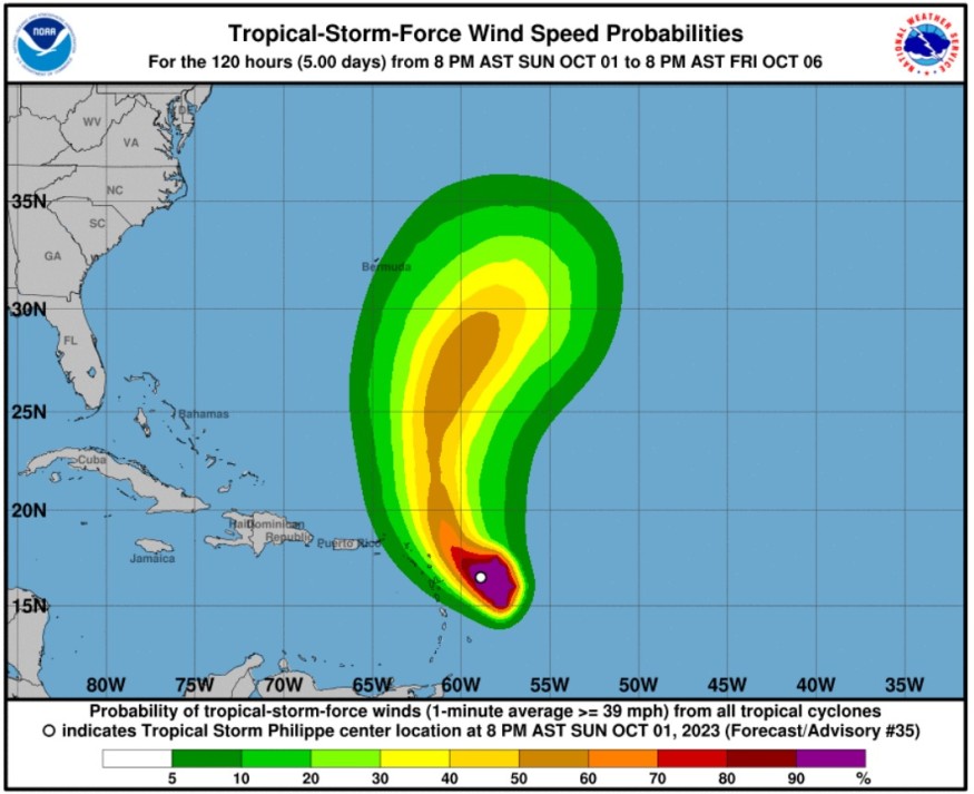
Philippe's track
The National Hurricane Center and Central Pacific Hurricane Center said that at 1100 PM AST (0300 UTC), the center of Tropical Storm Philippe was spotted near latitude 16.6 North, longitude 59.1 West.
Philippe is tracking the direction toward the west-northwest near 5 mph (7 km/h).
Weather experts said that a track toward the northwest is forecast on Monday followed by a northward motion by late Tuesday.
It was also observed in the forecast track that the center of Philippe is expected to pass near or just northeast of the northern Leeward Islands on Monday and Monday night.
Weather experts noticed that Philippe has moved rather slowly over the past several hours and the initial motion estimate is west-northwestward, or 300/4 kt.
Philippe is packing maximum sustained winds that are near 50 mph (85 km/h) with higher gusts.
Little change in strength has been forecasted during the next 48 hours, but the weather disturbance could begin to intensify more significantly around the middle of the week.
Furthermore, tropical-storm-force winds extend outward up to 175 miles (280 km), primarily east and southeast of the center.
Meanwhile, the estimated minimum central pressure is 998 mb (29.47 inches).
Weather experts said that Philippe is expected to produce the following rainfall amounts through Tuesday: Barbuda and Antigua: 4 to 6 inches, and the Rest of the Leeward Islands: 2 to 4 inches.
They warned that the amount of rainfall could result in isolated to scattered flash floods in the abovementioned areas.
When it comes to the wind, tropical storm conditions are possible in the watch areas by Monday morning.
Meanwhile, the swells generated by Philippe will affect portions of the Atlantic coasts of the northern Leeward Islands, the Virgin Islands, and Puerto Rico during the next few days.
These swells are likely to cause life-threatening surf and rip current conditions.
Residents in these areas are advised to consult their local weather office for further advisories.
According to meteorologists, the environment for Philippe in the short term does not appear conducive for significant strengthening, with fairly strong westerly vertical wind shear likely to continue to affect the system through Monday.
Moreover, when the system moves farther north over the Atlantic, it may encounter a region of reduced shear as indicated by some of the dynamical guidance.
More tropical threats
Aside from Philippine, weather experts are saying that tropical threats are seen to continue looming in the Atlantic and East Pacific Ocean Basins.
They said that in most cases, tropical activity will start winding down during the month of October as the season nears its end on November 30.
This year, meteorologists are keeping an eye on several threats into the first few weeks of the month.
They noted that locations that are closer to land may become more favorable locations for tropical development in the Atlantic.
Furthermore, an uptick in tropical activity across the East Pacific is common during the El Niño phenomenon.
Related Article : Tropical Storm Philippe Projected to Bring Heavy Rain, Strong Winds to Northeast Caribbean Region
Related Video:
© 2026 NatureWorldNews.com All rights reserved. Do not reproduce without permission.


