Challenging weather conditions are expected in parts of the Mid-Atlantic States, New England, Southeastern Virginia and New Jersey as Tropical Storm Ophelia moves over in Eastern Carolina on the weekend.
Americans with travel activities should check the weather outlook. According to the NWS report, the advisory warned of heavy rain, flash flood threats and coastal flooding.
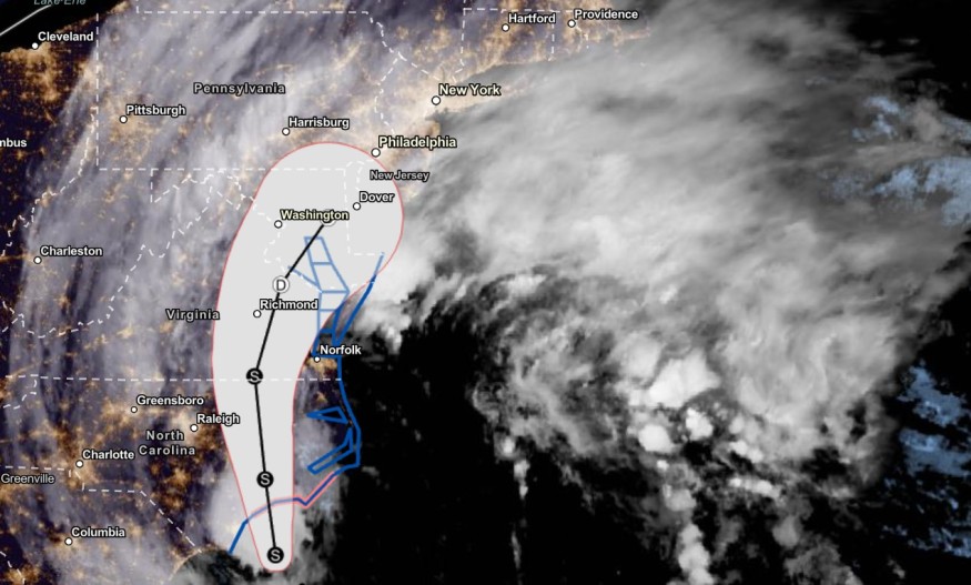
Tropical Storm Ophelia: Where will it impact?
The latest weather forecast showed that the tropical storm could bring possibly increasing heavy rainfall this weekend. The gusty winds can also cause downed power lines and trees. Residents should also expect possible power outages, especially in the affected areas.
As of Saturday, Tropical Storm Ophelia maintained a maximum sustained winds of 70mph and was located over Cape Fear in North Carolina.
The tropical storm is expected to land in Eastern Carolina on the weekend. The core of the storm is likely in the said areas with tropical storm-force winds.
On Saturday, North Carolina coast could experience coastal flooding. Meanwhile, heavy rain conditions and possible flash flooding can unload in the Mid-Atlantic states, New England, Southeastern Virginia, Eastern Maryland, Southern New Jersey and Delaware.
Storm Surge Warnings are also present in portions of the Chesapeake Bay Area and South Carolina. Weather alerts are issued in the following areas:
- Virginia Beach
- New Bern
- Williamsburg
- Chincoteague
- Morehead City
Travel concerns and flooding will be likely in the following areas:
- New York
- Wilmington
- Raleigh
- Richmond
- Washingon
- Boston
Due to the rainy conditions in the affected areas, a cooler outlook will unleash in Syracuse, Pittsburgh and Portland.
The Tropical Storm will likely weaken on the weekend. However, homeowners should stay alert to the impacts of the tropical storm.
Central US Weather Outlook
Meanwhile, NWS noted that a potent system was located over the Central US. Potential widespread thunderstorms can unfold in the Mississippi Valley and Central High Plains on the weekend.
The areas of concern are the Southern Plains and Middle Missouri Valley due to the heavy rain outlook. Motorists should watch out for possible lightning strikes on the weekend. The poor weather conditions can also spark potential flash flooding dangers.
For people expecting potential snow, high-elevation areas in Northwestern Wyoming can experience likely wet snow on Saturday.
Keeping safe from tropical storm outlook
Satefy is vital during severe storms and hurricanes. Homeowners should keep updated with the latest regional or national weather news forecasts.
Furthermore, limiting outdoor plans is recommended to prevent being stranded on flooded roads amidst the threat of heavy rain. Homeowners in low-lying or flood-prone areas should check the weather outlook.
Related Article : Stormy Conditions Likely in Eastern Florida, Southeast Coast Due to Developing Low-Pressure
For more similar stories, don't forget to follow Nature World News
© 2026 NatureWorldNews.com All rights reserved. Do not reproduce without permission.


