The latest weather forecast showed that a cooler weather outlook is expected in the Central US due to cooler air from high pressure from Canada.
Central US has experienced prolonged heat, bringing heat advisories and heat-related health concerns. The challenging heat increased the possibility of fire and dry conditions.
Areas in central US could finally receive the much-awaited relief from the heat starting Monday until mid-week. It will become ideal for Americans with outdoor activities, but it is best to bring an umbrella or raincoat protection at all times.
In the Northeast, the National Weather Service (NWS) said that the cold front could help ease the heat in the region, bringing excessive rainfall and thunderstorms.
Areas of heavy rain are expected in parts of the central and southern Plains (Kansas to Texas) in the next five days. The forecast calls for two to four inches of rain in this part of the country. One to two inch totals are possible in far southwest Arkansas.#arwx pic.twitter.com/nLcCior4M9
— NWS Little Rock (@NWSLittleRock) September 11, 2023
Central US cooler conditions: Where will it unload?
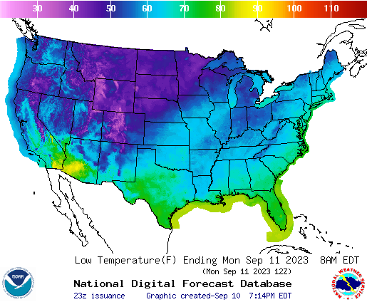
According to the latest forecast, the stormy weather outlook and the cooler air from Canada will push the cooler conditions in the Central US and Southern Plains starting Monday.
Temperatures are likely to fall between 10 to 25 degrees in parts of the Central US, with chances of rain and thunderstorms.
Starting Monday to Wednesday, the cooler conditions are expected in the following areas:
- Denver
- Omaha
- Wichita
- Chicago
- St. Louis
- Little Rock
- Oklahoma City
- Dallas
The rainy conditions are not expected to become severe. However, low-lying and flood-prone areas should always monitor the weather.
According to NWS Little Rock, the rainfall outlook could stretch from Kansas to Texas. Residents could expect two to four inches of rain. In the Southwest Arkansas, one to two inches of rain is possible.
In Kansas City, the advisory showed that widespread rain conditions and thunderstorms would unload on Monday. Temperatures are likely to hit the mid-70s until the week.
10:26pm...Showers with a few embedded thunderstorms are moving slowly east-southeast across the region, and will continue to do so overnight. Widespread heavy rainfall or severe storms are not expected. #kswx pic.twitter.com/qTkOdie3aO
— NWS Wichita (@NWSWichita) September 11, 2023
In Wichita, the NWS reported that light rain conditions could be possible in the region this week. Residents are warned of possible isolated lightning, especially at night. Temperatures are forecasted to reach around the mid-70s.
Meanwhile, hotter conditions could continue in the following areas:
- Odessa
- El Paso
- Houston
- Jackson
- New Orleans
- Austin
- Corpus Christi
As of September 9, dry conditions were predicted for Little Rock and parts of southwest Arkansas, including in the Pacific Northwest and Mid-Atlantic states.
The beneficial rain can also help ease the drought in the region.
Hurricane Lee forecast
Furthermore, the National Hurricane Center monitored the latest forecasts of Hurricane Lee. Forecasts said that it would be too soon to predict the impacts of Hurricane Lee.
5pm AST Sun Sep 10th Key Messages for #Hurricane #Lee.
— National Hurricane Center (@NHC_Atlantic) September 10, 2023
Hazardous beach conditions to spread across the western Atlantic this week. Too soon to know level of impacts for US East coast or Atlantic Canada late this week, so stay tuned for updates. https://t.co/w5INoaj9KX pic.twitter.com/NaXXHp21Mz
However, the advisory explained that dangerous surf and rip currents are forecast to hit the US East Coast in the late week, including in the following areas:
- Virgin Islands
- Puerto Rico
- Northern Leeward islands
- Turks and Caicos Islands
- Bahamas and Bermuda
The forecast said that it was too early to determine where the hurricane could make landfall. Affected residents should stay updated with the weather starting Monday.
Related Article : Powerful Hurricane Jova Likely to Bring Rough Surf, Rip Currents to Southern California, Mexico
For more similar stories, don't forget to follow Nature World News.
© 2026 NatureWorldNews.com All rights reserved. Do not reproduce without permission.


