Hurricane Jova is predicted to become a powerful hurricane in the Eastern Pacific. It is expected to bring strong winds and rough surf to the Gulf of Baja California, Mexico and Southern California.
According to forecasts, it is not yet expected to cause threat to land as it is predicted to weaken this weekend, especially its wind intensity.
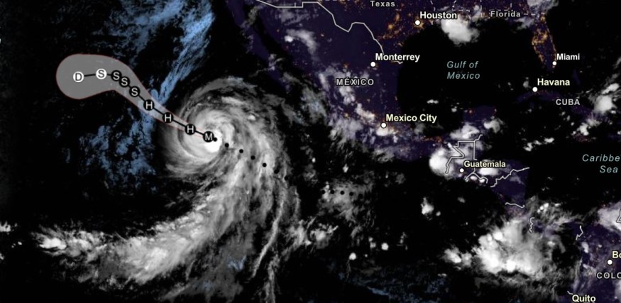
As of writing, it is not predicted to make any landfall.
As per the NOAA advisory, Hurricane Jova was last located over the southwest-southern tip of Baja California. The storm maintained maximum sustained winds of least 157 mph (252 km/h).
Beachgoers should check the latest forecast as the Hurricane could unleash dangerous surf conditions this week.
Powerful Hurricane Jova movement: Where will it make an impact?
September is expected to unleash significant hurricanes this month. Meanwhile, the National Weather Service (NWS) also monitored Tropical Storm Margot that moved towards the Eastern Atlantic.
The latest forecast added that Hurricane Jova has yet to impact land significantly. However, the storm will bring rough surf conditions, strong winds and rip currents. People going to sea should watch out for challenging waves.
Hurricane Jova showed an unusual buzzsaw shape, making it a powerful hurricane in the Western Hemisphere this year.
NWS Los Angeles advisory warned of possible coastal flooding and beach erosion due this week due to Hurricane Jova, especially in the following areas
- Crescent Ave. Avalon
- Long Beach Peninsula area
Before the Hurricane weakens this weekend, Jova is forecast to maintain its trajectory over the southwest-southern tip of Baja California. The following areas are expected to experience light to strong winds:
- Baja California
- Manzanillo
- Cabo Orientes
- Mexico coast
- Gulf of Papagayo
Furthermore, Central America could anticipate rising sea levels (4-6 ft). Rip currents could also become likely in the following areas:
- Columbia
- Ecuador
- Clarion Island
Also Read : Hurricane Lee Expected to Intensify Into Category 5; Deadly Rip Currents to Impact East Coast
Hurricane Lee impacts
Recently, the National Hurricane Center (NHC) also monitored the developments of Hurricane Lee. The advisory warned that it could become a major hurricane and is expected to become a Category 5 hurricane.
According to the forecast, Lee would bring rip currents in the following areas early next week:
- Puerto Rico
- Bahamas
- US East Coast
- Leeward Island
- Virgin Islands
- Caicos
- Hispaniola
- Turks
The impacts of Hurricane Lee can become more noticeable next week. In the US, the Hurricane could unleash dangerous surf on Sunday.
Check our latest update on Hurricane Lee for more information.
Preparing for hurricane conditions
Weather agencies are observing stormy conditions:
- Hurricane Lee
- Tropical Storm Margot
- Hurricane Jova
As storms strengthen into hurricanes, Americans should keep updated with the latest forecasts near their areas. Keeping a battery-powered radio is also helpful when power outages unfold.
People with travel plans should also check for possible flooded road conditions and landslides. Beachgoers are also at risk of coastal flooding or challenging waves.
As September becomes active in hurricanes, preparations are essential to prevent possible injuries or casualties.
Related Article : Possible Storm May Bring Rains to US; September Likely Become Active in Hurricanes
For more similar stories, don't forget to follow Nature World News.
© 2026 NatureWorldNews.com All rights reserved. Do not reproduce without permission.


