Weather experts said that the hurricane season this year could reach its climatological peak in the next few weeks.
In relation to this phenomenon, meteorologists have been monitoring two areas of weather disturbance which might undergo potential tropical development in the Eastern Pacific.
They suspected that one of these could hit Mexico over the weekend.
It is also expected that the two potential storms could threaten some parts of the United States.
Gulf of Mexico
Weather forecasters are all eyes on the area of low pressure that is presently near Central America. They are monitoring if this could form in a swath that will later stretch from the Gulf of Honduras into the Gulf of Mexico in the next several days.
Meteorologists said that if this weather system does evolve, it will most likely move towards the direction of Florida.
Still, it is too early to determine the timing and magnitude of the impacts of this possible weather disturbance, if any.
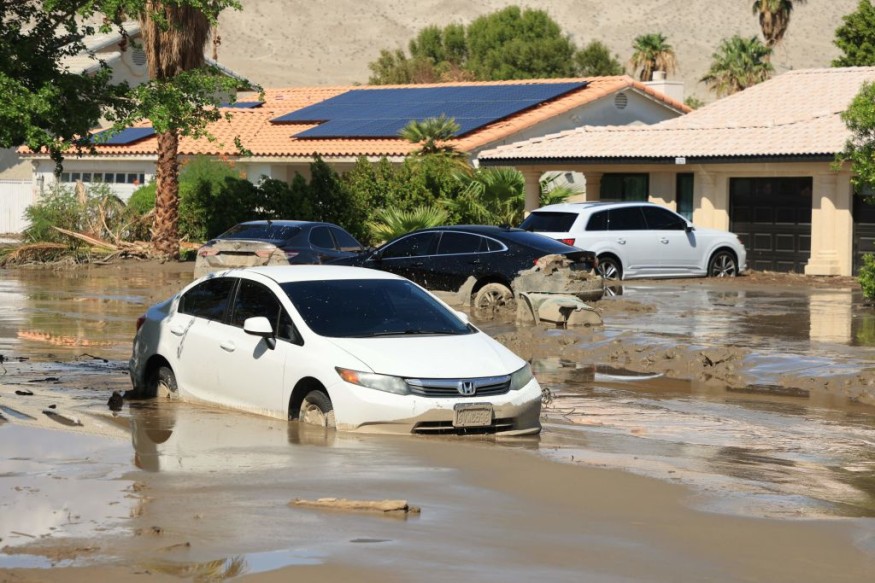
Earlier, Mexico was battered with Tropical Storm Hilary that brought heavy rains and massive floods in some areas of the country.
To recall, Hilary formed as a tropical storm off the coast of Manzanillo, Mexico earlier this week and as it further enhanced and strengthened, it began moving west-northwest toward the Baja California.
Officials had warned of catastrophic and life-threating floods in Mexico as well as in the southwestern US due to the torrential rains brought by Hilary.
The possible storm that will hit Mexico is seen to center at a few hundred miles offshore of the coast of southern Mexico.
Because of this, weather officials said that due to the mountainous terrain landscape in the area, the expected atmospheric flow in the coming days should preclude much moisture from moving to the north.
Meteorologist La Troy Thornton said that the possible storm would bring enhanced rainfall across a different swath of the country that is "no stranger to tropical cyclones."
Experts already observed that showers and thunderstorms were already evident in some areas based on satellite imagery off the Mexican coast.
They explained that there would be a little possibility for the weather system to strengthen beyond a tropical storm status, however, this should not appease residents as this does not discount the possibility for the system to reach the hurricane status.
It is also expected that once the system develops, it will make landfall late Saturday or Sunday.
"Regardless of development status or strength, heavy rain appears likely to travel up the coast of southwestern Mexico into the weekend. The coastal states most in line for potential tropical impacts extend from Oaxaca to Jalisco," Thornton said.
Steering winds in the Pacific
On the other hand, meteorologists are also keeping an eye on the steering winds in the Pacific that are blowing to the west.
They, however, noted that the budding tropical system would only pose a minimal threat to the land area despite the prospects of a developing and strengthening tropical system because of the warm ocean waters.
Weather experts said the storm, once developed, would track generally the western section.
Related Article : Hilary Strengthens to Hurricane: Major Flash Flooding Likely in Southwestern U.S., California
Related Video:
© 2026 NatureWorldNews.com All rights reserved. Do not reproduce without permission.


