The latest forecast revealed that flash flooding is possible in the Southwestern U.S. as Tropical Storm Hilary developed.
Americans with scheduled travels should check the latest forecasts to avoid possible travel headaches and concerns. Motorists can also expect slower commutes due to the inclement weather.
Recently, the Southwestern U.S. experienced record-high heat, especially in California. The challenging heat brought heat-related health concerns and increased fire risk in the region.
However, the rainy conditions can ease the extreme temperatures in the region this week.
The beneficial rain can also improve the drought outlook in the Southwest.
Tropical Storm Hilary's possible impacts
The latest forecast showed that Tropical Storm Hilary managed to reach maximum sustained winds of 40 mph.
There is a possibility that the storm could strengthen.
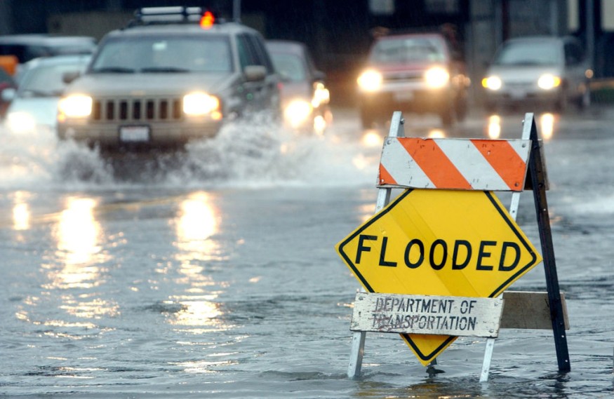
Tropical Storm Hilary can impact parts of the Southwest and Eastern Pacific. Residents in low-lying or flood-prone areas should check for a rapid floodwater rise this week.
On the weekend until Tuesday, the weather outlook warned of potential mudslides and flash flooding in the following areas:
- Cedar City
- Elko
- Phoenix
- Carson City
- San Bernardino
- Phoenix
- Hermosillo
- Las Vegas
Furthermore, the NHC Eastern Pacific reported that Tropical Storm Hilary could also affect parts of Baja California and Southwestern Mexico.
Here is the latest forecast info for Tropical Storm Hilary from @NWSNHC:
— NWS Los Angeles (@NWSLosAngeles) August 16, 2023
- Hilary forecast to become a major hurricane Fri night
- Hilary is forecast to impact #SoCal as a tropical storm on Mon
- 20-30% chance tropical storm-force winds, beginning as early as Sun evening#CAwx pic.twitter.com/mf6xU1OkDL
The forecast noted that people should keep updated with the advisories for the storm's development. A severe thunderstorm watch was also issued in parts of Wisconsin and Minnesota.
Meanwhile, the NWS Los Angeles reported that rainy conditions could unload in L.A. Counties and Ventura.
Thunderstorm conditions could emerge in California Valley, Santa Barbara County, Antelope Valley and San Gabriel Mountains.
From Saturday to early next week, thunderstorms and rain showers are likely in the following areas:
- Las Vegas
- Tucson
- Cedar City
- Phoenix
- Billings
- Los Angeles
- Miami
- Jacksonville
Hotter conditions will continue in Memphis, Dallas, Houston, El Paso, Kansas City, Denver and Minneapolis.
In the Atlantic Ocean, weather agencies are monitoring the possible developments of three tropical waves.
Keeping safe from tropical storms, hurricanes
As the hurricane season begins, it is expected that hurricane-force winds and extreme heat could unload. Hurricanes can strengthen and become powerful, causing significant damage to houses, properties, power lines and trees.
Here are essential reminders to keep safe from severe weather, including hurricanes and tropical storms.
Prepare multiple information of news alerts
Homeowners should check multiple sources of weather news alerts, including on computers, mobile phones, radio or televisions.
A battery-operated radio is helpful during power outages.
Be ready to evacuate
People should be ready to evacuate when floodwaters rapidly rise or local officials announcements. If it is safe, it is best to secure your home, especially toxic or flammable materials.
Avoid power lines or trees, as thunderstorms or lightning strikes are possible.
Keep emergency supplies
Homeowners should also keep emergency supplies. In addition, a ready-go emergency bag will be a lifesaver when you evacuate.
For more similar stories, don't forget to follow Nature World News.
© 2026 NatureWorldNews.com All rights reserved. Do not reproduce without permission.


