The severe weather risk is not yet over in the Midwest, as rounds of flooding, rainfall and thunderstorms could hit this week. There is a possibility of isolated tornadoes.
People with travel plans should observe the weather outlook before leaving their homes, as a severe outlook could lead to slower commutes and dangerous travel.
Recently, Nature World News (NWN) reported that over 60 million Americans in the Midwest were at risk of rounds of severe thunderstorms.
The early start of August erupted oppressive heat conditions in parts of the country, causing dangerous heat and health concerns. July noted as the hottest month on record due to soaring temperatures, according to the United Nations News.
Severe weather outlook in the Midwest
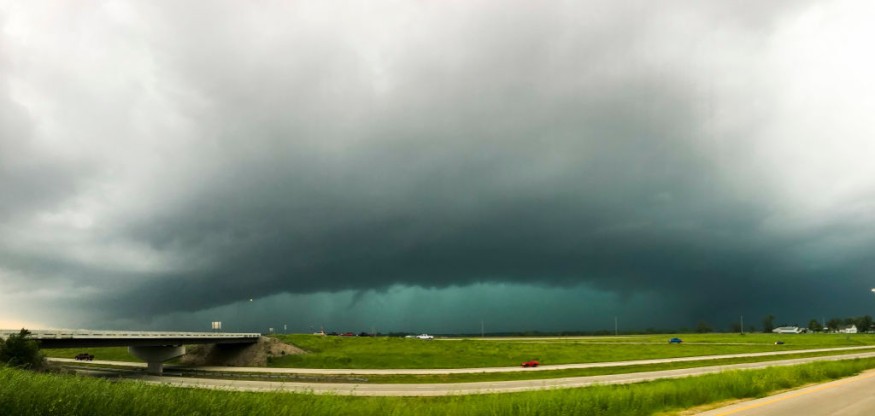
In the recent AccuWeather forecast, rainy conditions were expected in Midwest on Sunday, especially in Minneapolis, Detroit, Sioux Falls, and Omaha.
On the same day, AccuWeather warned of possible isolated tornadoes and flooding downpours in Des Moines, Indianapolis, St. Louis, Charleston, Pittsburgh, Nashville and Birmingham.
The forecast said the rain could lead to slower commutes and travel disruptions in the early week.
In addition, the forecast noted the potential risk of multiple tornadoes.
Meanwhile, the NWS Eastern Region reported that thunderstorms and damaging winds could unload in Eastern US, Southern and Central Appalachians and Mid-Atlanic.
Furthermore, the NWS Raleigh showed that severe thunderstorms could reach portions near I-95.
Moreover, the advisory added that large hail and local flash flooding could be likely.
Meanwhile, the NWS Tornado showed that tornado watch was present in portions of Missouri, Illinois and Iowa.
The NWS Weather Prediction Center said Central US could likely experience heavy rainfall. Dry conditions are expected in portions of the Southwest.
Preparing for the severe weather risk
Heavy rainfall and flash floods could result in dangerous situations. Americans should keep updated with the weather outlook this week.
Here are essential reminders to keep safe from the weather.
Watch out for flooding watch and concerns
Homeowners near flood-prone areas should stay alert for the rapid rise of sea or river water. Homeowners should immediately evacuate when officials announce.
Secure your outdoor equipment
The latest weather showed that strong or damaging could be likely this week. Homeowners should secure all their outdoor equipment to avoid being blown away.
Furthermore, regular roof checking is recommended, as the hurricane season has already started.
Limit outdoor activities
Homeowners should limit any outdoor activities. Motorists could expect slower commutes and travel disruptions. Driving slowly under rainy conditions is essential to prevent road accidents.
Prepare emergency kits
A car and home emergency kits are essential during severe weather conditions or powerful hurricanes.
Roads can become inaccessible and widespread power outages are also possible. Emergency kits are helpful or a life-saver.
Did you know?
According to NOAA, Hurricanes can form in tropical waters, which can develop in warm oceans. When hurricanes strengthen, they are seen moving in a circular motion called closed circulation.
Related Article : US Weather Forecast: 60 Million People Under Severe Weather Risk in Midwest; Isolated Tornadoes Possible This Weekend
For more similar stories, don't forget to follow Nature World News.
© 2026 NatureWorldNews.com All rights reserved. Do not reproduce without permission.


