A flash flood emergency has been issued in the state of Kentucky by the state's local National Weather Service (NWS), as drenching thunderstorms swept through the region. Raging floodwaters due to heavy rainfall affected some parts of western Kentucky, affecting several counties. The emergency alert means multiple areas are at risk of disruptive, damaging, or life-threatening flash floods.
The Kentucky thunderstorms also pose risks of large hail, destructive winds, and even isolated tornadoes, as observed from previous weather events across the state in recent years. The current severe weather also flooded homes and made some roads impassable. No casualties, including deaths and injuries, have been reported yet amid the adverse weather.
The Kentucky weather is expected to improve in the coming hours and days, leading to the weekend. Although temperatures are possible to increase during the said period, the occurrence of severe weather is still possible in the state. This comes as the U.S. has been currently over a month since its summer and Atlantic hurricane season started.
Kentucky Flash Flood Emergency
The NWS office in Paducah, Kentucky, warned that the flash flood damage threat can be "catastrophic" for the counties of Ballard, Carlisle, and Graves, which are all situated in the western part of the state, specifically north of the Tennessee border, as cited by AccuWeather.
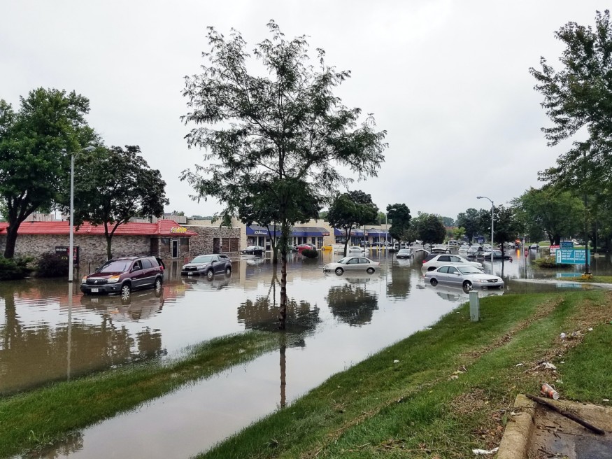
The Kentucky flash flood emergency came after severe storms released 4 to 6 inches of rain across the region as of 6 a.m. CDT (local time) on Wednesday, July 19. Since the said period, multiple water rescue operations have been conducted in the Kentuckian city of Wingo, located around 10 miles along the Tennessee-Kentucky border, according to the NWS.
Kentucky Thunderstorms
Water rescues were also conducted in the city of Mayfield, Kentucky, as floodwaters pummeled through homes in some areas of the state, according to The Weather Channel.
Mayfield is the same city that suffered from a powerful EF4 tornado back in December 2021 amid severe thunderstorms.
According to the Kentucky government, every thunderstorm contains lightning and series of storms that can produce heavy rain, strong winds, hail, and potentially tornadoes.
On average, Kentucky receives approximately between 40 and 60 thunderstorms each year, which varies depending on the location within the state. The most frequent thunderstorm activity has been recorded during the summer months, according to the website WeatherSTEM.
Kentucky Weather Forecast
Meteorological experts have associated the July heavy rain phenomenon with other major thunderstorms. Meanwhile, similar events have been linked to the potentially deadly inclement weather in Kentucky and its surrounding regions. Although no significant updates have been sent yet, U.S. weather authorities are still monitoring the weather developments in the country.
Amid the threat, local officials advised residents in flood-hit areas in Kentucky to evacuate. Jeremy Creason, the Mayfield Fire Chief, told FOX Weather that further flooding is expected as another weather system is coming later on Wednesday.
This means that renewed torrential rain and flash flooding are possible not only in Kentucky but also in other states across the central and eastern U.S. in the coming days.
© 2026 NatureWorldNews.com All rights reserved. Do not reproduce without permission.


