A 7.6 magnitude earthquake occurred in the Banda Sea, Indonesia, as reported on the early morning of Tuesday, January 10, causing powerful seismic waves in some provinces of Indonesia and a part of northern Australia.
There were no immediate reports of fatalities but the tremor cause the injury of at least one person and led to the damage of multiple structures, including buildings.
Indonesia Earthquake
The epicenter of the earthquake is situated between the countries of Indonesia, Timor-Leste, Papua New Guinea, and Australia.
However, media reporting said the quake originated from the Anbar Sea, as mentioned earlier, but in the Tanimbar Islands Region of Indonesia.
There has been contradictory estimation between seismologists, including those from Indonesia and the United States, with regard to the actual magnitude of the earthquake.
However, the difference is still small as the seismic event still caused widespread disruption across the region.
An updated report from Indonesia's Meteorology Climatology and Geophysics Council (BMKG) said the intensity of the earthquake was 7.9 and was situated 134 kilometers northwest of the province of Maluku, Indonesia, as confirmed by an unnamed seismologist.
Meanwhile, the U.S. Geological Survey (USGS) said the quake's magnitude was 7.6 with a depth of 105.1 kilometers with a time occurrence of 1:47 a.m. on Tuesday.
Following the main identifiable earthquake, the USGS reported several aftershocks in the area, with intensity ranging between 4.1 and 5.4 magnitudes.
Earthquake Impact
Dubbed as a "deep-sea earthquake," its impact damaged village buildings in a lightly-populated group of islands in eastern Indonesia and was widely felt in northern Australia.
The seismic wave from the Banda sea earthquake was powerful enough to damage at least two school buildings and 15 houses in the Tanimbar islands, where one resident was injured.
Locals felt strong tremors spanning from three to five seconds.
There was also panic when the earthquake shook the island, prompting the residents to leave their houses, according to a statement by Abdul Muhari, spokesperson of the National Disaster Mitigation Agency, as cited by ABC News.
In addition, tremors were also felt in several regions in the country, including the Indonesian provinces of Papua and East Nusa Tenggara.
Meanwhile in northern Australia, the shock of the quake was felt by more than 1,000 people, including in the city of Darwin, who reported to Geoscience Australia about their immediate experience after the quake.
The Joint Australia Tsunami Warning Centre stated the Indonesian quake did not pose a tsunami threat to mainland Australia or any of its islands or territories.
Pacific Ring of Fire
Earthquakes are common in Indonesia since it is situated in the Pacific Ring of Fire, also called as the Girdle of Fire or the Circum-Pacific belt, a horse shoe-shaped region across the Pacific Ocean where seismic activity is strong.
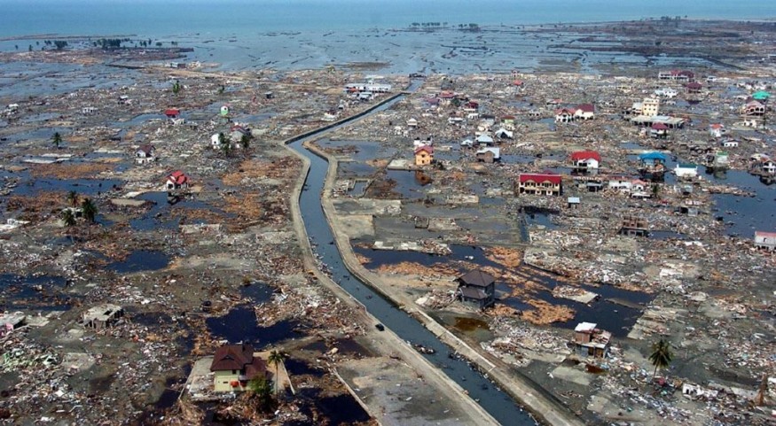
In 2004, a 9.1 magnitude earthquake occurred off the Sumatra island in northern Indonesia, which triggered a deadly tsunami that hit 14 countries, killing 226,000 people along the coastline of the Indian Ocean; with more than 50% of them in Indonesia, according to CNN.
© 2026 NatureWorldNews.com All rights reserved. Do not reproduce without permission.


