The weather prediction for California in the United States is not promising. The San Francisco Bay region was being battered by stormy weather and rainfall. This might result in rising rivers and flooding.
In its forecast, the National Weather Service warns of a "relentless procession of atmospheric rivers" in the following week. According to the meteorological service, this will bring snow and severe rain.
California braces for heavy weather
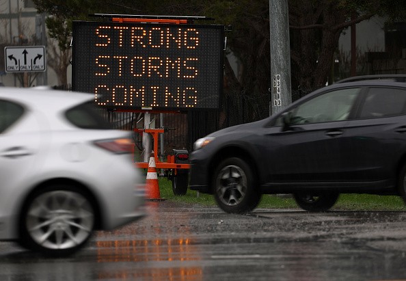
California prepared for more extreme weather on Sunday, following a week of torrential downpours and devastating winds that killed at least 12 people and knocked out electricity to hundreds of thousands of homes and businesses, as per Reuters.
The National Weather Service cautioned that northern and central California remained in the line of a "relentless parade of cyclones," with no reprieve expected until the middle of the week.
Over the last week, two overlapping phenomena an enormous airborne stream of concentrated moisture from the ocean known as an atmospheric river and a widespread, hurricane-force low-pressure system known as a bomb cyclone have triggered deadly floods and record snowfall.
Sacramento Valley is experiencing "strong winds with gusts up to 60 mph," according to the National Weather Service's Sacramento office on Sunday. The heavy weather forecast follows days of rain in California from Pacific storms, as per The Economic Times.
"Widespread power outages, toppled trees, and poor driving conditions are possible," the National Weather Service's Sacramento office tweeted.
Damaging winds will return again later this evening through tomorrow as the next winter storm arrives to interior #NorCal.
— NWS Sacramento (@NWSSacramento) January 8, 2023
Widespread power outages, downed trees and difficult driving conditions will be possible.
Secure your loose outdoor items! #CAwx pic.twitter.com/gc4iDgHIBb
On Monday, a powerful storm is expected. Rain of 15 to 30 millimeters is anticipated on Wednesday, according to the meteorological service.
Since December 26, San Francisco has gotten 25 cm of rain. According to the National Weather Service, popular ski destination Mammoth Mountain received 3 meters of snow.
US approaches the midpoint of meteorological winter
As the country enters the thick of winter and approaches Groundhog Day on February 2, some regions are wondering where the season has gone, with minimal snow and temperatures that would make any snowman wince, as per Fox Weather.
Apart from an arctic blast in December, general temperatures have been above average and precipitation has been below average in sections of the Northeast, Ohio Valley, and southern Rockies.
The lack of freezing precipitation is due in part to a weather pattern flow that has prevented large storms from tapping into plentiful moisture.
One of the locations experiencing a snow shortage is the Interstate 95 corridor. Boston has received around a foot less snow than usual, while New York City has received half a foot less.
The mild weather in the eastern United States has also resulted in a lack of ice in the Great Lakes.
Lakes Superior, Michigan, Huron, Erie, and Ontario had only around 4% ice coverage as of early January.
A new year typically begins with coverage in the double digits, gradually increasing to roughly 44 percent around the peak in late February.
According to the most recent data, Lake Superior had the greatest ice, while Lake Ontario had the least, accounting for less than 1% of total ice coverage.
Over 80 inches of snow fell in western New York in November, creating thousands of power outages and killing at least four people.
A month later, hurricane-force winds and feet of snow covered the region, killing more than three dozen people.
Historically, the lake-effect snow pattern has been known to shut down when the lakes freeze over, making adequate moisture for air masses more difficult to access.
© 2026 NatureWorldNews.com All rights reserved. Do not reproduce without permission.


