New England is likely to receive a downpour of rain and snow by the end of the week due to a looming coastal storm, according to US weather authorities. The severe weather will affect mostly the northern parts of the region, causing potential flight disruption. power outages, and other security risks.
Coastal Storm Warning
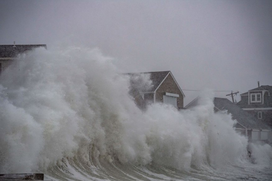
The Weather Prediction Center (WPC) of the National Oceanic and Atmospheric Administration (NOAA) - National Weather Service (NWS) on Wednesday, April 27, issued a weather warning for New England as a low-pressure area is strengthening over the Gulf of Maine and has been forecasted to "pivot" near the Bay of Fundy from the evening.
The potent storm system may produce torrential rain and higher elevation snow that will cover most of upper New England, notably Northern Maine which may reportedly experience snow accumulations of up to four to eight inches.
The weather forecast indicates the coastal storm will be equivalent to impacts caused by a minor winter storm. The specific dissipation of this adverse weather is not yet determined, as it will slowly move as it may linger near Greenland, as per the US weather agency.
The NOAA - NWS weather alert will be in effect until Saturday, April 30. However, the update or issuance of new weather advisories is still possible in the coming hours and days.
The weather phenomenon this week is expected. In fact, AccuWeather meteorologists on April 16 issued their forecast that a Nor'easter will cause a blast of winter in late April, affecting multiple cities such as New York City, Richmond, Philadelphia, Boston, Washington, and other areas across the Northeast.
Other Areas Affected
Until late Friday, April 29, northwesterly winds and snow showers will cover the region. Moreover, the cold air will flow across the Northeast and Mid-Atlantic in the next few days with below-average temperatures. It may possibly reach the Midwest and the northern Plains.
Furthermore, freezing temperatures may also occur in the Midwest, Ohio Valley, and Mid-Atlantic, where "Freeze Warnings" are in effect from Thursday, April 28, until Friday, as per the NOAA - NWS.
Thunderstorm and Fire Weather
Meanwhile, the Storm Prediction Center (SPC) of the NOAA - NWS also issued a thunderstorm warning for scattered strong to severe thunderstorms across western Nebraska for Thursday.
The thunderstorm alert also highlights the occurrence of severe weather from Texas into western Oklahoma in the afternoon or evening. In addition, severe storms are also possible as far as Idaho and western Wyoming.
Under thunderstorms, there is a risk of flash floods due to heavy rain, damaging winds, and isolated tornadoes. Since March, a number of thunderstorm-driven tornadoes affected the central, southern, and eastern portions of the US.
In Iowa, a tornado outbreak killed a total of seven people in early March.
By month's end, a series of tornadoes amounting to approximately 30 tornadoes due to inclement weather affected seven states in the Midwest and Southern US, with two people killed in Washington County, Florida, according to ABC News.
On the other hand, the SPC on Thursday also issued a warning for critical fire weather conditions across the southern High Plains and the southern Rockies. Such climatic conditions, including humidity, wind pattern, soil moisture, and hot temperature, will increase the risk of wildfires.
© 2026 NatureWorldNews.com All rights reserved. Do not reproduce without permission.


