The latest weather report warned that a storm could become a bomb cyclone, unloading heavy rain, strong winds, mudslides and flooding in portions of California.
The forecast added that potential power outages and significant travel delays could be expected.
People in the affected areas should keep updated with weather forecasts and developments as the storm could result in life-threatening flooding rainfall, and strong winds.
Recently, the weather forecast warned that the atmospheric river could unload moisture-packed storms in portions of California.
The start of the year would be challenging as the storm could unleash severe weather conditions this week starting Wednesday and Thursday, January 4 and January 5.
Recently, CNN News reported that flooding rainfall unloaded in California that could continue until this week.
Heavy rain and flooding
Meanwhile, AccuWeather's latest forecast this January 4, showed that the storm on the California coast could bring mudslides, flooding rainfall, power outages and avalanche risk.
The forecast showed that the storm could unload starting Wednesday until Thursday, affecting portions of Medford, Redding, San Francisco, Reno, Los Angeles and Bakersfield.
- On the same day, strong winds could unleash that could cause downed trees and power lines.
- Residents in Los Angeles, Sacramento and San Francisco could expect heavy rain. Potential flash floods and mudslides could occur.
- Due to persistent rain, the forecast emphasized that the rain with atmospheric rivers could result in serious flooding in Northern and Central California.
With the storm rapidly intensifying, the forecast explained that heavy rain could, with strong winds persist this week, causing potential mudslides.
AccuWeather forecasted emphasized that the stormy weather could cause widespread flooding and heavy snowfall.
Although the rain could benefit drought-stricken areas, flooding concerns could still emerge.
Due to the threat of the storm, the report said that officials announced evacuation advisories: in San Mateo County and Watsonville.
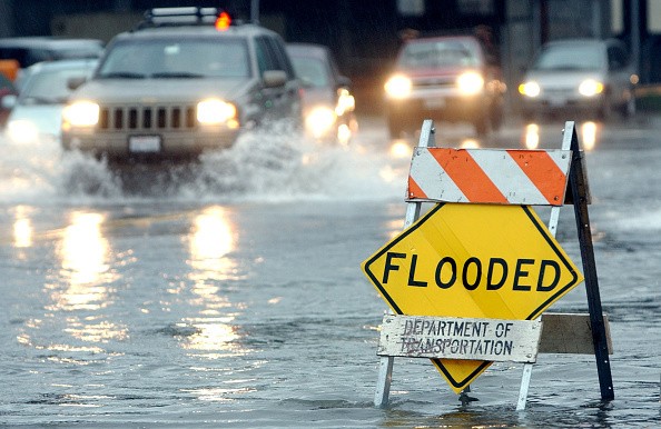
Meanwhile, the National Weather Service (NWS) said heavy rain could result in road closures, collapses and debris.
Motorists driving at night should drive cautiously due to wet roads.
The advisory said residents should remain alert for potential floods or when they live in flood-prone areas.
Motorists should observe the current weather and forecasts before departing. Significant delays and slowed commutes are expected due to potential flooding. Road closures could also occur.
Weather safety and preparations
Being prepared during a storm unloading flooding rainfall is important. The forecast said the storm was rapidly strengthening and could become a bomb cyclone.
Stay alert with weather advisories.
Keep updated with weather alerts from your local weather stations or officials. Monitor the storm's development, especially if your area could be hit.
It is important to evacuate when your area is flood-prone or when instructed by the local authorities.
Keep your emergency supplies and kits
A handy emergency bag would be the best during a storm. You could bring it inside your car when traveling or evacuating.
The emergency bag should include the following emergency kits:
- Medicine kit
- Flashlight and a battery-powered radio
- Food supply with bottled water
- Power bank
- Raincoat and blankets
Related Article : Heavy Snow to Unfold in Upper Midwest and Northern Plains in First Week of January; Motorists to Expect Slowed Travel
For more similar, don't forget to follow Nature World News.
© 2026 NatureWorldNews.com All rights reserved. Do not reproduce without permission.


