After a prolonged break in an activity that has lasted more than a month, a new tropical depression is anticipated to emerge in the Atlantic Ocean this week. The National Hurricane Center in Miami, Florida, reports in this afternoon's Tropical Outlook that there may be favorable circumstances for the formation of a tropical depression.
However, they caution that the predicted adverse atmospheric conditions after the week may impede progress then.
Recent Forecast
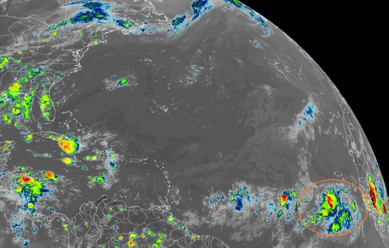
The most recent imagery from NOAA's GOES-East weather satellite depicts a region where showers and storms develop to the equator's north and west. A tropical wave is linked to this extensive band of showers and thunderstorms across the eastern tropical Atlantic south of the Cabo Verde islands. The National Hurricane Center reports that although this system's organization hasn't changed much today, environmental factors appear to be favorable for gradual development over the coming days as it moves across the eastern and central tropical Atlantic at 15 to 20 mph in a westward to west-northwesterly direction.
As the system travels west over the open seas of the Atlantic Ocean, the National Hurricane Center predicts that a tropical depression might develop by the middle to end of this week. The National Hurricane Center does note that by this weekend, conditions are anticipated to become less favorable for further intensification. According to the National Hurricane Center, a tropical cyclone is expected to form here over the next 48 hours, with a 40% probability over the following five days.
More Tropical Cyclones?
The National Hurricane Center predicts that no more tropical cyclones will form anyplace else in the Atlantic Hurricane Basin for at least the next five days. Up to the end of November, the Atlantic hurricane season for 2022 will be in effect.
The tropics are expected to become much more active in the upcoming weeks, resulting in a season with above-normal hurricane and tropical storm activity.
Extreme Weather Events
The 2022 Atlantic hurricane season is still expected to be above average, according to NOAA's annual mid-season report, released today by the Climate Prediction Center, a part of the National Weather Service.
As the storm season enters its height, Secretary of Commerce Gina Raimondo urged everyone to exercise caution. For the duration of hurricane season and beyond, NOAA specialists will continue to offer the research, data, and services required to assist communities in becoming storm resilient and climate-ready.
Season Forecast
From a 65% possibility in the prediction released in May, NOAA forecasters have marginally reduced the chances of an above-normal Atlantic hurricane season to 60%. The chances of near-normal activity have increased to 30%, while the possibilities of a below-normal season have stayed at 10%.
"NOAA stands ready to deliver timely and accurate forecasts and warnings to help communities prepare in advance of approaching storms," said NOAA Administrator Rick Spinrad, Ph.D. "We're just getting into the peak months of August through October for hurricane development, and we anticipate more storms on the way."
Related Article : Exposure to Major Disasters Can Cause Long-Term Mental Health Problems
For more climate and weather updates, don't forget to follow Nature World News!
© 2026 NatureWorldNews.com All rights reserved. Do not reproduce without permission.


