The fourth tropical storm named in the East Pacific basin erupted on Saturday and exploded into a strong major hurricane over the region's open waters early this week.
According to AccuWeather experts, Hurricane Darby is particularly amazing to see since the tropical cyclone's path has resulted in magnificent weather photography.
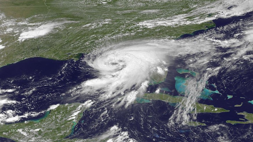
Darby Intensifying
Darby quickly intensified late Sunday, and it was a Category 4 major hurricane (sustained wind speeds of 130-156 mph or 209-251 km/h).
According to the International Meteorological Organization, rapid intensification increases a tropical cyclone's maximum sustained wind speed of at least 35 mph (55 km/h) in 24 hours (National Hurricane Center).
It is now 5 a.m. Darby had sustained winds of 105 mph (165 km/h) at HST Wednesday, designating it as a Category 2 Hurricane.
According to the NHC, the whirling tropical feature was positioned 1,335 miles (2,150 km) east of Hilo, Hawaii.
Darby was traveling west at 16 mph (26 km/h).
Started as a Tropical Storm
Darby began as a tropical storm Saturday afternoon just offshore of Mexico's southern coast (sustained wind speeds of 39-73 mph or 63-118 km/h).
As the storm moved westward over the weekend, it found atmospheric conditions favorable for additional tropical development, such as warm sea temperatures and minimal wind shear.
Darby took advantage of the chance to build and attain Category 1 hurricane classification on the Saffir-Simpson Hurricane Wind Scale on Sunday night (sustained wind speeds of 74-95 mph or 119-153 km/h).
The cyclone grew in power over the next several hours as it raged across the open Pacific.
"On satellite imagery, Hurricane Darby showed a remarkable round of rapid strengthening Sunday night into Monday morning, revealing a near-symmetric form," AccuWeather Meteorologist Brandon Buckingham stated.
"Because of Darby's tiny size, this storm was able to take advantage of favorable climatic circumstances fast," Buckingham explained.
Growing Stronger
Darby grew from a 65-mph (105-km/h) tropical storm to a 120-mph (193-km/h) Category 3 major hurricane in less than 24 hours, from Sunday afternoon to Monday morning.
Darby is the season's second significant hurricane in the Atlantic and East Pacific basins.
Satellite footage showed that the cyclone had begun to develop an eye late Sunday night into early Monday am. Darby's eye grew more noticeable on Monday.
A hurricane with a well-defined eye usually indicates a highly intense storm.
When fully charged, Darby is not projected to track close to any land masses.
According to experts, Darby is not projected to directly strike any land at hurricane or tropical storm strength as the cyclone weakens as it moves through the East Pacific and into the Central Pacific basin this week.
Darby will confront increasingly adverse air conditions as it swings westward into Hawaii this week.
"Darby is predicted to dissipate before it approaches the Hawaiian Islands," said Buckingham. "At this time, the most noticeable effects over the Hawaiian Islands will likely be greater surf, particularly along eastern facing beaches."
Darby moisture will very likely surge into Hawaii this weekend, increasing rainfall in the area.
The system is anticipated to be a tropical depression or rainfall.
For a period, localized flash flooding risks may arise in locations caught in the greatest downpours or sustained rounds of rain, particularly on the Big Island.
Hurricane Season
Darby is the fourth named tropical cyclone in the East Pacific this season; however, it is the fifth named storm overall to move across the basin.
Hurricane Bonnie accomplished a remarkable accomplishment earlier this month when it traveled from the Atlantic basin into the East Pacific.
As it crossed basins, the storm retained Bonnie and was not assigned a name from the preset East Pacific list.
Bonnie was the season's first significant storm in the Atlantic and East Pacific basins.
Related Article : Exposure to Major Disasters Can Cause Long-Term Mental Health Problems
For more climate and weather updates, don't forget to follow Nature World News!
© 2026 NatureWorldNews.com All rights reserved. Do not reproduce without permission.


