While the Bureau of Meteorology predicts a respite in the torrential rain, emergency services in New South Wales warn citizens that floodwaters might continue to rise, posing a threat to communities.
Floodings
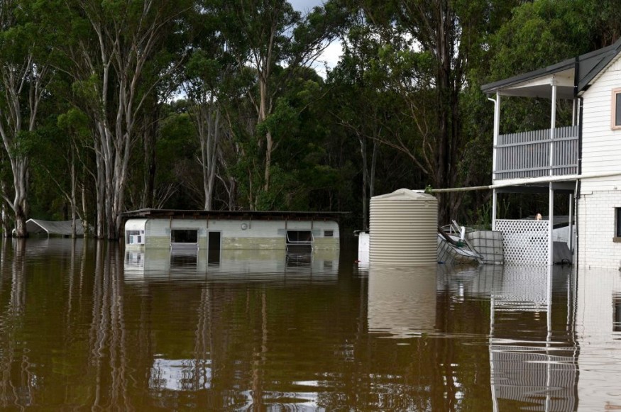
It comes as the Hawkesbury River, which is flooded in Sydney's northwest, threatens thousands of houses in low-lying regions with severe flash floods, as reported by 9News.
By lunchtime on Wednesday, the river was expected to reach 14.3 meters, which is around one meter higher than the level achieved during the floods of 2021.
No Flood Warnings
Residents of the Hawkesbury Nepean River have been given a flood warning, with heavy flooding occurring in North Richmond, Windsor, Sackville, Lower Portland, and Wisemans Ferry.
After 24 hours of torrential rain, the agency performed 71 flood rescues around Sydney and received more than 2000 calls for assistance.
Sydney has received over 900mm of rain since January 1st.
Wet weather records are being smashed, according to BoM forecaster Dean Narramore. "With 872.4mm, this year's start to a year is the wettest on record; the previous record was 815.8mm in 1956," he stated.
According to the agency, Sunshine is expected in the following days, but flooding remains a severe threat to towns.
Evacuations
Approximately 60,000 people in New South Wales awoke this morning to evacuation orders, and warnings as the state's flood disaster continued, with 61 evacuation orders still in effect.
Communities around Singleton in the Hunter area, including Glenridding, Dunolly, and Combo, were ordered to evacuate overnight.
Others, such as those for Sussex Inlet and St Georges Basin, remain in force on the South Coast. The west and south-west parts of Sydney, including Camden, the Hawkesbury, and suburbs along the Georges River, are the most hit.
Authorities in Sydney's Northern Beaches have encouraged people to watch the situation after roads and houses were extensively damaged by yesterday's pounding rain. The roads around Manly Vale and the Roseville Bridge are still flooded. People should minimize nonessential travel, according to SES Assistant Commissioner Dean Storey.
"I believe the main message this morning when people wake up and leave their houses is to avoid needless travel if you're in flood-affected regions," he added. Storey stated that "vast swaths" of the state were still impacted. Today's forecast in Sydney includes very severe winds with gusts up to 90 km/h, as well as hazardous surf.
Strong and severe gusts have been cautioned to anyone who plans on fishing, swimming, or boating. According to Jackson Browne of the Bureau of Meteorology, Winds will diminish during the day.
Browne added that when the rain system goes out to sea, Sydney would only have "nuisance showers" today, but flood dangers persist.
"Thankfully, the falls out to the Hawkesbury and Nepean catchments are roughly 25mm to 40mm," he added. However, it's vital to note that they had considerable rain in the preceding 24 hours, which is why the river system is once again flooded.
The Hunter Coast, Sydney Coast, Illawarra Coast, Batemans Coast, and Eden Coast are all under a separate severe weather warning for dangerous and destructive surf.
Gosford, Maitland, Sydney, Penrith, Parramatta, Wollongong, Nowra, Bowral, Batemans Bay, and Goulburn are expected to impact the bureau.
No More Heavy Rain
The BoM says heavy rain is no longer forecast on Wednesday; thus, the current warnings have been lifted. However, the coast got a soaking on Tuesday night, with moderate falls visible on the radar.
However, hazardous flooding is expected to persist in the coming days, with many flood warnings in effect throughout the state.
Floodwaters have isolated Mulgrave, putting communities in the region at risk of being cut off. Wallacia is also experiencing major floods, with significant flooding reported at Menangle Bridge and Camden.
The St George's Basin has also been updated with a moderate flood warning, with Island Point Rd approaching a peak and the Sussex Inlet possibly reaching the intermediate flood level, with evacuation orders in effect for people in both places.
Around 1.45 a.m., the SES issued an evacuation order for people in Scone's low-lying districts, joining a slew of other places asked to abandon their homes in the previous 12 hours.
For more climate and weather updates, don't forget to follow Nature World News!
© 2026 NatureWorldNews.com All rights reserved. Do not reproduce without permission.


