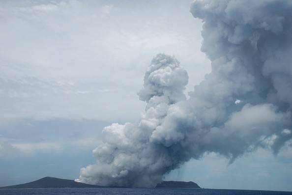
The explosion of the Hunga Tonga-Hunga Ha'apai volcano is considered the greatest eruption on the planet in the last 30 years, according to reports. Shock waves were heard as far away as Alaska, tsunami waves raced across the Pacific Ocean, and the ash plume rose high into the sky. Tonga was covered in ash.
Geoscientists employing satellite data to monitor changes in the Earth's surface temperature were less surprised by the Tonga volcanic eruption than the rest of the world. But the surprising force of the eruption left the world in shock.
Predicting Volcanic Eruption
Last year's eruption of the Cumbre Vieja volcano on the Spanish Canary Island of La Palma was less explosive but lasted over three months, whereas the Tonga eruption was tremendous but brief.
Both of these recent volcanic eruptions serve as a stark reminder of the destructive power of nature. Humans might be closer to predicting eruptions if they had a better knowledge of the natural processes taking place beneath their feet.
In the Science for Society 3D Earth project, an international team of geoscientists worked together to create the world's most advanced global model of the Earth's lithosphere, which includes the brittle crust, upper mantle and sub-lithospheric upper mantle beneath 400 kilometers of the planet's crustmantle.
In-situ measurements, principally seismic tomography, are combined with other satellite data, such as gravity data from ESA's GOCE.
As per Phys.org, researchers predicted that these volcanoes will erupt in their model, which depicts temperature variations or the thermal structure of Earth's upper mantle. It is, however, more difficult to predict exactly when this might occur.
Also Read : Scientists: Disastrous Tonga Volcano Eruption 500 Times More Powerful Compared to Hiroshima
Formation of Back Arc Volcanoes
Complutense University of Madrid researcher Javier Fullea explained that the WINTERC-G, which analyzes in situ tomographic and GOCE satellite gravity data, reveals a branch of the Azores plume.
Located near the base of the upper mantle, it can be seen from Earth's surface down to a depth of 400 kilometers. Madeira and the Canary Islands are surrounded by the cold mantle beneath the north Atlantic's African edge, which is fed by the plume.
This volcano is located in an arc basin formed by the subduction of the Tonga slab, which researchers can see all over the world. As the cold slab descends into the mantle, it is thought that back arc volcanoes form.
From such models and seismic tomography, researchers detect structures growing from vast depth beneath the Canary Islands. Known as hotspots or plumes, these anomalies represent heated material rising to the surface of Earth and are a constant source of volcanoes on the surface, according to ESA.
There are two distinct volcanoes that make up the Hunga Tonga-Hunga Ha'apai cluster. In the Tonga-Kermadec arc, the Pacific tectonic plates merge with the Australian Plate. Above the plunging Pacific Plate researchers can see the layer of partially molten rock that feeds the volcanic arc.
Origin of Thermal Anomalies
At a depth of around 2800 kilometers, a structure known as the Large-Low Seismic Velocity Provinces (LLSVP) sits at the core-mantle border and provides the answer (LLSVPs). The surface behavior appears to be greatly influenced by these large continent-sized formations.
Convection cells driving plate tectonics are linked to major plume locations, according to Clint Conrad of Norway's Centre for Earth Evolution Dynamics.
Plume material is pushed against the LLSVPs by the flow along the core-mantle boundary, resulting in plumes. In models, the downwelling slabs that surround the two LLSVPs are responsible for this flow. For example, the Canary Islands sit above the African LLSVP.
In any case, it is still unclear how the LLSVPs got their start and how they've evolved over time. Satellite data and seismological models were used during a recent 4D Earth Science workshop to generate new hypotheses about the Earth's interior, which could lead to more detailed investigations in the near future.
Clearly a multidisciplinary approach is needed, where different types of satellite data are merged with seismological data in a common method to address the exact structure of Earth's deep interior, says Bart Root, one of the organizers of the meeting.
It's encouraging to see that the FutureEO Science for Society project, headed by ESA's Diego Fernandez, is delivering insights that will help better understand the deep-lying origins of extreme weather events like those in La Palma and Tonga, Root said.
For more news, updates about volcanoes and similar topics don't forget to follow Nature World News!
© 2026 NatureWorldNews.com All rights reserved. Do not reproduce without permission.


