Researchers from Stanford University are starting to use maps, satellite data, as well as artificial intelligence to assist in predicting blazes as the West and California seem to be having more wildfires as if the pandemic is not enough of a problem already.
In order to anticipate the places where it is likely to have fire as well as how the blaze could spread, scientists endeavored to obtain landscape-wide information on the amount and dryness of plant materials that are likely to burn. Such information is hard to obtain, especially with a speed and scale that are helpful for the management and prevention of wildfires.
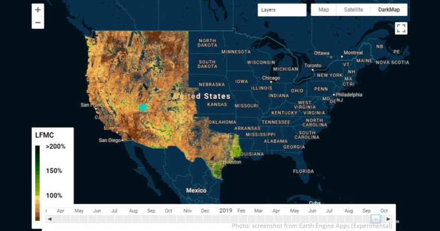
Now, researchers are using a model that can map the dryness of vegetation in the forest in 12 states in the west, including Wyoming, Texas, Montana, Colorado, and the Western Pacific coast. It is deep-learning, and it maps in great detail the level of fuel moisture.
Senior author and Stanford University earth system science assistant professor Alexandra Konings says that this can drastically improve studies on wildfires. The report is published in the Remote Sensing of Environment Journal.
Lead author and earth system science Ph.D. student Krishna Rao says that the proposed model still needs to be tested for situations that need decisions on fire management, which affect homes and lives. For now, it is already shedding light on new patterns never seen before.
Read also: Tropical Forests Can Tolerate a Warmer Planet Upon Climate Change, but Only Within Limits
This is a perfect time for this model, what with the combined and compounded problems brought by climate change and the ongoing coronavirus pandemic. Both have the potential to intensify wildfires while limiting available mobilization and help.
Fire agencies and researchers measure moisture and dryness by weighing the dry weight of tree branches after drying them in an oven. According to Konings, it is a very laborious process and cannot encompass all the landscapes and species where they would like to get data.
Although the U.S. Forest Service assiduously collects such plant moisture data, no information exists regarding changes in time or between plants and between ecosystems. Only guesses exist regarding the factors of precipitation, temperature, dead plant moisture, and live plant dryness.
Now, however, Rao says they can establish the link that connects weather and moisture of live fuel in various ecosystems in the western part of the U.S. Their new model utilizes A.I. that can detect patterns present in tons of available data.
Researchers used the model on field moisture data and let it estimate the fuel moisture of two kinds of measurements from sensors in space. The first measures light bouncing from our planet, and the second is SAR or synthetic aperture radar, which gets measurements from returning signals from microwave radar. The latter penetrates leaves, branches, and down to the surface of the ground.
Konings also used data from newer satellites that use longer wavelengths that can collect data that take water into account and actually represents fuel moisture. They validated the model by feeding data worth three years from 239 sites from 2015 onwards.
They also looked at predictions of fuel moisture from six land cover types, such as sparse vegetation, broadleaf deciduous forest, shrubland, needle leaf evergreen forest, and grasslands. Shrublands proved to be the most congruent with actual field measurements; shrublands, according to Rao, cover 45 percent of the western U.S., which is the largest ecosystem in the region and are very susceptible to wildfires. Fire agencies monitor chaparrals intensively.
Results from the model are formed into a map that is interactive and useful for identifying patterns as well as prioritizing measures for control.
© 2026 NatureWorldNews.com All rights reserved. Do not reproduce without permission.


