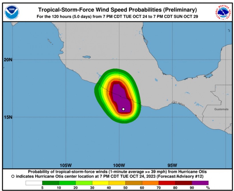
Weather experts said that Hurricane Otis is expected to unleash heavy rains over Mexico as Category 5 storm.
Based on the latest forecast, Otis has been drifting northward toward the coast of Mexico.
Officials said that Otis is likely to undergo additional strengthening before making a landfall along the Mexican coastline.

Otis' Track
The National Hurricane Center and Central Pacific Hurricane Center said that at 1000 PM CDT (0300 UTC), the center of Hurricane Otis was spotted near latitude 16.1 North, longitude 99.7 West.
Otis is tracking the direction toward the north-northwest near 9 mph (15 km/h), and this general motion is expected through for the next day or so, with landfall forecast overnight or early on Wednesday in southern Mexico.
Meteorologists said that satellite data has indicated that the maximum sustained winds have increased to near 160 mph (260 km/h) with higher gusts.
They said that Otis is a Category 5 hurricane on the Saffir-Simpson Hurricane Wind Scale.
Furthermore, weather experts noted that Otis is forecasted to remain a category 5 hurricane through landfall, and rapid weakening is then forecasted due to the higher terrain of Mexico.
Moreover, Otis will likely dissipate over southern Mexico on Wednesday night.
Meanwhile, the hurricane-force winds extend outward up to 30 miles (45 km) from the center and tropical-storm-force winds extend outward up to 70 miles (110 km).
On the other hand, the estimated minimum central pressure is 927 mb (27.38 inches).
Officials warned that catastrophic damage is possible where the core of the hurricane moves onshore.
Authorities already raised warnings to ensure the safety of residents.
A hurricane warning is in effect for Punta Maldonado westward to Zihuatanejo while a hurricane watch has been raised over Lagunas de Chacahua to Punta Maldonado.
On the other hand, a tropical storm warning is in effect for Lagunas de Chacahua to Punta Maldonado
Experts explained that a hurricane warning means that hurricane conditions are expected somewhere within the warning area, in this case within 12 hours.
A hurricane watch, meanwhile, means that hurricane conditions are possible within the watch area, in this case within the next 12 hours.
Moreover, a tropical storm warning means that tropical storm conditions are expected somewhere within the warning area.
Read Also: Hurricane Tammy Seen To Cause Structural Damage In Lesser Antilles
Tammy Moving Over The Atlantic
Meteorologists are also monitoring Tammy, which is a Category 1 hurricane packing maximum sustained winds of 85 mph as it spins to the northeast of Puerto Rico.
Weather experts will continue to track the weather system towards the north over the next few days as it moves away from the Caribbean.
Tammy is seen to maintain its hurricane strength through at least midweek and it can lose wind intensity throughout the day on Thursday.
It will encounter strong wind shear or disruptive winds in the atmosphere, which will later affect tropical cyclone organization.
Meteorologists said that the impacts from Tammy could be felt across the islands of Bermuda later this week.
Related Article: Hurricane Tammy Pummels North Caribbean with Large Waves, Heads Toward US by End of Week
Related Video:
© 2024 NatureWorldNews.com All rights reserved. Do not reproduce without permission.


![Climate Change is Reducing Dust Levels Worldwide as Arctic Temperature Warms [Study]](https://1471793142.rsc.cdn77.org/data/thumbs/full/70320/280/157/50/40/climate-change-is-reducing-dust-levels-worldwide-as-arctic-temperature-warms-study.jpg)
