The mid-month of April will bring colder conditions to parts of Montana and Wyoming, according to a National Weather Service (NWS) advisory. The weather forecast monitors the development of a cold front, which can help with the temperatures in the chilly temperatures in the region.
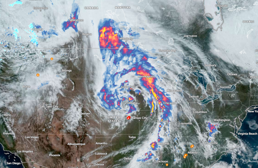
NWS forecast shows that severe weather is likely in the Lower Great Lakes and Ohio Valley on Wednesday. In a recent Nature World News (NWN) report, portions of the Southern US have experienced severe weather threats, bringing isolated tornadoes, hail, and thunderstorms.
The forecast monitors the development of a storm system in the Central Plains, which can impact portions of the Great Lakes region this early week. Potential thunderstorm conditions can unload in the Corn Belt southward to the Ozarks on Wednesday.
Weather Conditions in Northern Rockies, Wyoming, and Montana
The latest NWS weather report reports moderate to locally heavy mountain snow in parts of the Northern Rockies. Nearby residents can experience chillier weather. Threats of hypothermia and frostbite are unlikely, but it is advisable to avoid prolonged exposure to cold weather.
The colder conditions can continue in the Upper Great Lakes and northern Rockies. On the other hand, warmer conditions can continue in the South and Desert Northwest. The chilly weather outlook can be ideal for outdoor activities, but homeowners should stay alert for slower commutes and slippery roads associated with potential snowfall.
Additionally, the colder weather outlook can unfold in eastern Montana and northern Wyoming. Potential snow conditions can unload on Wednesday. In the Central Plains, there is a chance of rain on early Thursday.
As mentioned, portions of the Southwest US can experience warmer temperatures reaching into the 80s and 90s. NWS Los Angeles advisory shows that cold wet weekends can be likely in April. Recently, LA experienced flood advisories and concerns due to rainy conditions.
Meanwhile, San Diego residents can anticipate warmer conditions on the weekend, with the warmest outlook possible on Sunday. Homeowners are advised to watch out for potential triple-digit temperatures in the low desert, with temps reaching 5 to 10 degrees below average.
In Salt Lake City, the advisory reveals that a relatively fair weather outlook is likely in the region. The forecast monitors the development of a weak boundary in northern Utah, bringing moderate temperatures through Friday.
Midwest Weather Forecast
In the latest weather advisory, potential damaging storms are likely in the Midwest through midweek, with a chance to become severe. About 35 million people could be affected by the severe weather outlook in the region, causing potential impacts on outdoor activities.
In midweek, the severe thunderstorms can unleash flash floods, hail, and isolated tornadoes in the following areas:
- Chicago
- Indianapolis
- Columbus
- Charleston
- Nashville
- Pittsburgh
- Cleveland
Related Article : Mid-Atlantic Weather Forecast: Severe Storm to Bring Hail, Damaging Winds This Week
For more similar stories, don't forget to follow Nature World News.
© 2026 NatureWorldNews.com All rights reserved. Do not reproduce without permission.


