The latest weather report reveals that severe storms are likely in the Southern US this week, bringing risks of large hail, flash floods, and isolated tornadoes. Homeowners should keep alert for threats of nocturnal tornadoes and severe weather.
People traveling this late this week are advised to keep updated with Thunderstorm Watch and Thunderstorm Warning. The National Weather Service (NWS) warns of heavy rainfall and flooding concerns in the Lower Mississippi Basin this week. Major flooding risk is likely in the West Hobolochitto Creek near McNeil.
In New Orleans and the Southwestern US, motorists should stay alert for impassable roads due to flooding concerns in the metro. Commuters can likely experience slower commutes, slippery roads, and road closures this week. If travel is not extremely important, staying at home is advisable to keep safe from challenging weather.
Additionally, the NWS forecast shows that severe weather and Flash Flood risk can unload on the Gulf Coast. Residents should stay alert for weather warnings and Flash Flood emergencies, particularly in flood-prone areas. Recently, South Texas was under a Severe Thunderstorm Watch.
Weather in the Southern US: From Isolated Tornadoes to Damaging Winds
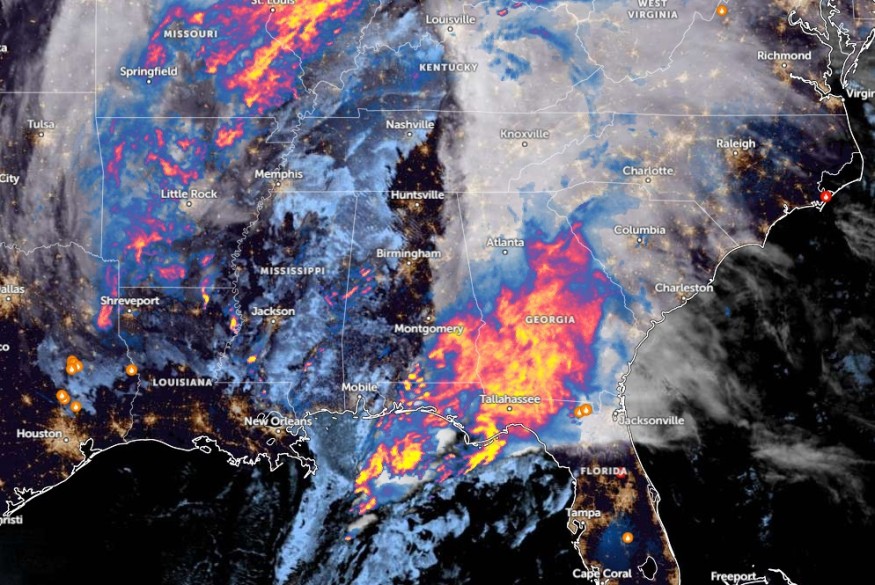
According to a weather advisory, severe storms can unleash high winds, flash flooding, and large hail this late week, with a chance of isolated tornadoes. Homeowners are advised to remain alert to the latest forecasts, especially for storm-prone areas in the Southern US.
From southern Mississippi to southern Alabama, there is a high risk of challenging storms in the region, including in the Florida Panhandle. In the midweek, the severe storm can threaten in the following areas:
- Little Rock
- Monroe
- Jackson
- New Orleans
- Tupelo
- Atlanta
- Montgomery
- Tallahassee
The widespread damaging winds can reach 60 to 70 mph, causing potential damage to properties and infrastructure. Homeowners should also anticipate potential power outages due to strong winds. In the late week, the severe storm can likely bring potentially isolated tornadoes and strong winds to the following areas:
- Raleigh
- Fayetteville
- Charleston
- Savannah
- Jacksonville
In Little Rock, the latest advisory shows that a wind advisory is present due to wind gusts reaching from 35 to 45 mph and possibly 50 mph. Additionally, thunderstorms and rain are likely in western Arkansas.
In Houston, a Special Marine Warning is present from High Island to Freeport TX, staying updated for potential waterspouts and steep waves.
Also Read : Weather Preparations Help Adapt to Climate-Related Threats Amidst Concerns of Frequent Storms
Weather Advisory in the Southern US: How Can Homeowners Prepare?
The latest weather report raised concerns about potential severe weather in the Southern US this late week, bringing threats of isolated tornadoes and stormy conditions. For homeowners, limiting outdoor travel is recommended to keep them safe from the weather and being stranded on the roads.
In addition, thunderstorms can unload. When tornadoes or thunderstorms occur, it is best to evacuate to secure areas, away from trees, powerlines, windows, doors, or fragile materials.
Related Article : Wyoming, Colorado Weather Forecast: Scattered Snow Showers, Thunderstorms to Hit This Week
For more similar stories, don't forget to follow Nature World News.
© 2026 NatureWorldNews.com All rights reserved. Do not reproduce without permission.


