A volcano on the Reykjanes peninsula in Iceland erupted in the early hours of Sunday, prompting lava to spill into the town.
The Icelandic MET Office said the eruption near Hagafell-Grindavík has maintained the same strength in the previous hours.
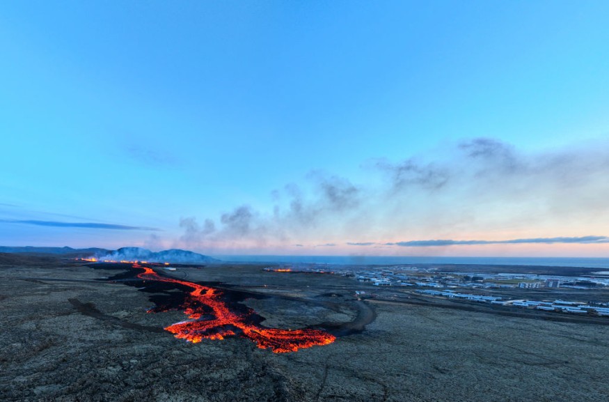
Lava Flowing To Grindavik
Experts said that seismic measurements had shown that at the beginning of the unrest, the magma filled dike intrusion initially moved from the southeast edge of Stóra-Skógfell and then it continued southwest to the southern end of Grindavík.
Researchers said that the seismicity had reached the northern end of Grindavík and both seismicity and deformation measurements indicate the dike has since propagated beneath Grindavík town.
Meanwhile, a new eruptive fissure opened in the afternoon, just north of the town. Lava flows extruded from this fissure have now entered the town, affecting residents in the area.
Due to the dike propagation, existing faults and fractures were reactivated and likely new fractures formed within Grindavík.
On Saturday, Iceland's National Commissioner of Police ordered residents in Grindavík, first evacuated in November, to leave again by Monday night after volcanic fissures opened on roads in the area.
Sixty households, or 10% of the town's usual population, have been evacuated so far,
Following the eruption, police authorities have already raised the alert level.
Meanwhile, an Icelandic Coast Guard helicopter has also been deployed to monitor the situation and ensure the lives of residents.
Hours before the eruption, Iceland's meteorological office had reported an earthquake.
Initially, the Icelandic MET Office updated the hazard assessment map for the Grindavík - Svartsengi region due to the ongoing unrest at the Reykjanes Peninsula.
As before, the map had shown an assessment of existing hazards that could occur with little warning within the specified regions.
Experts said that the assessment only applies for hazards within the defined areas, although hazards are possible beyond the confines of the assessed regions.
The overall assessment for the six zones remains unchanged from the previous map. However, there is a change in the hazard assessment associated with fissures within Grindavík.
The hazards associated with sudden opening of mapped and unknown fissures within Grindavík has been deemed higher.
Experts advised that it should be noted that the hazards associated with fissures is limited to known areas within the municipal boundaries.
Unless otherwise stated, the warning raised by officials as well as their maps regarding this are valid until Tuesday, January 16.
Gas Distribution
Furthermore, the Icelandic MET Office's weather forecast said that the gas distribution from the eruption at Hagafell has indicated that the direction is north and northeast, with a speed of 3-8 m/s, with the weather being dry and bright.
Weather forecasters will be cloudy at times with minor snowfall late tonight and tomorrow morning.
It is also forecasted to clear up in the afternoon tomorrow. Meanwhile, the pollution from the eruption is spreading towards the south and southwest direction.
To recall, strong earthquake tremors preceded the December eruption in the Svartsengi volcanic system. In the weeks since, walls were built around the volcano to direct molten rock away from Grindavík, which is considered as a home to some 4,000 people.
Related Article : Iceland Volcano Erupts Near Capital After A Strong Earthquake Struck
© 2026 NatureWorldNews.com All rights reserved. Do not reproduce without permission.


