The latest weather forecast showed that an intensifying low-pressure system will bring a stormy outlook from the Eastern Seabord to New England, causing travel dangers for Americans with Holiday plans.
According to the NWS Tampa Bay, a storm system is expected on the coast. The forecast warned of increasing tornado threat and strong winds in the early week.
In New York City (NYC), the forecast warned of a coastal storm in the city, bringing heavy rain and damaging winds. Isolated flash flood threat is possible in the early week. The Southerly winds can reach from 55 to 60 mph.
Flood-prone areas are at risk of moderate to severe flooding in parts of the US, including in NYC. People should stay alert to Flood Watch Advisories.
Intensifying Low-Pressure System: Where Will It Unload?
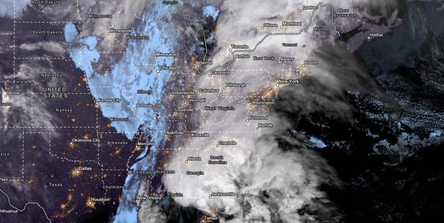
The NWS Weather Prediction Center reported a strengthening low-pressure system from the Gulf of Mexico to the East Coast. Homeowners should stay alert for coastal flooding and gusty winds on Monday.
In Buffalo, residents can expect a warm and breezy air. The rain is expected to move from west to east. People with travel plans should check for soaring rain in the early week.
On the weekend, the National Weather Service (NWS) warned of severe thunderstorm risk in the Mid-Alantic Coast. In the Great Lakes, lake-effect snow is also likely.
In addition, NWS Discussion reported a strong storm in the Gulf Coast of Florida. NWS monitors an area of low pressure in some parts of the Mid-Atlantic to New England.
Homeowners should stay alert for excessive rainfall on Monday. The main dangers are urban flooding, road concerns and flash floods due to heavy rain.
The stormy outlook can unload showers and severe thunderstorms in Eastern North Carolina and Eastern Southern Carolina. Isolated tornadoes and hail conditions are also likely on Monday.
People traveling this week should check for Flood Watch and Concern, especially in flood-prone or low-lying areas. When the weather worsens, it is best to stay at home as much as possible.
How to keep safe from Intensifying Low-Pressure System
The challenging weather is expected in parts of the US as Christmas comes near. Weather preparedness is essential for homeowners and motorists in the Northeast and Pacific Northwest.
Here are essential reminders for homeowners traveling this week in the US.
- Homeowners should monitor the latest forecasts in the Northeast, Eastern Seaboard and Pacific Northwest.
- Motorists should check for flooded roads and dangers before traveling. Flight cancellations and delays are possible.
- Having emergency kits is also possible. They should keep survival kits, including battery-powered flashlights, medicine kits, food supplies and bottled water.
Related Article : Northeast Weather Forecast: Travel Dangers Likely Before Christmas
For more similar stories, don't forget to follow Nature World News
© 2026 NatureWorldNews.com All rights reserved. Do not reproduce without permission.


