Tropical Storm Bolaven will bring damaging winds and heavy rain to Guam this week. Residents are advised to check the weather regularly.
Challenging weather conditions are expected in Guam due to a tropical storm. Motorists with travel plans should check for flooded roads due to Stormy Bolaven.
The tropical storm's main concerns are flooding rainfall and damaging winds this week.
Tropical Storm Bolaven: Where will it impact?
The tropical storm is forecast to intensify this week in parts of Guam rapidly. Communities in flood-prone areas can be at risk of potential flooding due to heavy rain outlook.
— NWS Guam 🇬🇺 (@NWSGuam) October 7, 2023
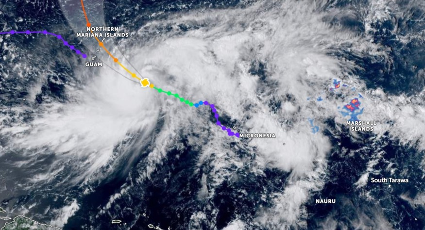
According to the latest weather report, Tropical Storm Bolaven was tracked near the East-Southeast of Guam and Saipan's southeast with maximum sustained winds up to 60 mph.
The tropical storm was seen moving northwest at eight mph.
Residents can anticipate damaging winds and heavy rain conditions, especially in the areas of the Mariana Islands.
A Tropical Storm warning and typhoon watch are issued in Guam. Communities can anticipate possible winds up to 39 mph. People with travel plans are advised to monitor the weather due to troublesome winds, especially for people going near the beach.
Furthermore, Typhoon watch is present in Saipan, Tinian and Rota portions. Residents should check the local weather reports and typhoon-force conditions.
On Tuesday, the tropical storm could track areas in Tia and Rota. The brunt of the storm can be likely in the midweek. Surf hazards can also, make it more dangerous for beachgoers.
Meanwhile, the local governments are also preparing for the impacts of the storm.
In the Eastern Pacific, the National Weather Service (NWS) warned of heavy to excessive rainfall from the developing Hurricane Lidia. South Texas may suffer from flooding rainfall this Tuesday or Wednesday.
Meanwhile, the National Hurricane Center (NWS) monitors a low-latitude wave in the Eastern Tropical Atlantic. The wave has a high chance of developing.
Staying safe from hurricanes and stormy conditions
The latest weather reports revealed the stormy outlook in Guam this week. Although fall weather begins, there is still the possibility of hurricanes in the US.
Here are essential reminders to keep safe from poor weather conditions.
Watch out for flooding concerns
One of the main concerns is the flooding rainfall. Homeowners should stay alert for small flooding. It is best to stay away from floodwaters, especially for motorists.
Limiting outdoor travel is also suggested to prevent possible weather dangers.
Keep home emergency supplies
Severe weather conditions can result in inaccessible roads and power outages. Storing emergency supplies can save your family, particularly prolonged flooding concerns.
Homeowners can keep emergency food supplies, bottled water, medicine kits, battery-operated flashlights and radios. In addition, a go-to bag is also helpful.
Related Article : Strong Cold Front to Bring Cooler Weather From Midwest to East Coast With Chance of Snowflakes
For more similar stories, don't forget to follow Nature World News.
© 2026 NatureWorldNews.com All rights reserved. Do not reproduce without permission.


