Experts predict that the Northeast US will see a wet summer until the season's end as torrential rains that cause flash floods continue to saturate the region.
Wet Summer in Northeast US
The summer of 2023 in the Northeast won't be known for scorching heat, but rather for relentless torrential rains and flash floods. Meteorologists are warning that this risk lingers even as summer nears its end.
Resurgence of severe storms, flash flood risk coming to Northeast https://t.co/JbG15oADIS via @accuweather
— Black Gloves Lady (@BlackGlovesLady) September 12, 2023
Since June 1, much of New England has seen rainfall levels surpassing historical averages, with some areas receiving over 2 feet of rain. Recent heavy downpours triggered flash floods from New Jersey to New Hampshire. Fitchburg, Massachusetts, endured nearly 5 inches of rain in mere hours, causing major flooding, submerged vehicles, and even sinkholes. Leominster, Massachusetts, declared a state of emergency due to a vulnerable dam.
New York City's Central Park experienced rapid flooding, with 0.94 inches of rain within an hour, impacting evening traffic. Over the weekend, Dallas to Clarks Summit, including Scranton, Pennsylvania, faced 4 inches of rain in a short time, resulting in flash floods and a tragic drowning incident in Lackawanna County.
Torrential Rains and Flash Floods
After a relatively calm Tuesday in the Interstate 95 corridor of the mid-Atlantic and New England, an approaching cold front, accompanied by increased moisture, will trigger more storms on Wednesday. On Tuesday night, this front will bring torrential rain and locally strong thunderstorms in areas spanning from Ohio to western Pennsylvania, West Virginia, and western New York, as well as portions of Maryland and Virginia. These conditions could result in travel delays during rush hour in cities like Pittsburgh, Cleveland, and Buffalo.
According to AccuWeather meteorologist Joseph Bauer, the first storms are expected to form on Wednesday morning in areas including central and eastern Pennsylvania and central New York, where torrential rain and localized flash flooding are the main dangers. On Wednesday afternoon and evening, as the day warms up, more powerful thunderstorms may develop from the mid-Atlantic to southern New England. These storms could impede travel in major transport hubs like Philadelphia, New York City, and Boston and even lead to aircraft ground stops.
Flash flooding will be the biggest threat posed by the storms by Wednesday afternoon into the evening across the Northeast, according to AccuWeather meteorologist Brandon Buckingham.
A downpour of between one and three inches of rain is possible in the space of only a few hours, which is a sufficient amount to overflow some storm drains and pool in low areas along local roads and highways. Because of the saturated nature of the land and the slow evaporation rates in September, rapid flooding of tiny streams is also a possibility.
Also Read : Kilauea Eruption After 2 Months of Silence Sends Warning Status to WATCH/ORANGE, Volcanic Smog Possible
PLUS: Severe Storms, High Winds, Hail
In addition to the flash flooding risk, there's potential for severe storms with high winds, hail, and even a few tornadoes. The greatest tornado threat spans from upstate New York's Hudson Valley through Connecticut to western and central Massachusetts on Wednesday afternoon and early evening.
After the front passes, cooler and less humid air will sweep eastward from the Midwest on Thursday and Friday. While not the coolest or driest, it will allow residents to switch off air conditioners and open windows. Nighttime temperatures will dip into the 40s and 50s over the Appalachians and the mid-50s to lower 60s along the I-95 corridor late in the week.
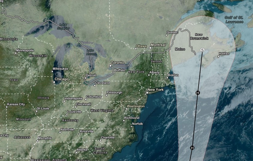
However, AccuWeather experts warn of potential disruptions from Hurricane Lee in eastern New England, western New England, and the upper mid-Atlantic coast over the weekend. Lee's track could bring wind, rain, and storm surge, especially to central to eastern Maine, though problems may extend farther west and southwest of its landfall. AccuWeather will provide ongoing updates on Hurricane Lee and other Atlantic tropical systems.
© 2026 NatureWorldNews.com All rights reserved. Do not reproduce without permission.


