Weather experts disclosed that Hurricane Lee is rapidly intensifying to Category No. 5, with threats expected in beach areas early next week.
According to the National Hurricane Center and Central Pacific Hurricane Center, dangerous beach conditions are expected to develop around the Western Atlantic through early next week due to Lee.
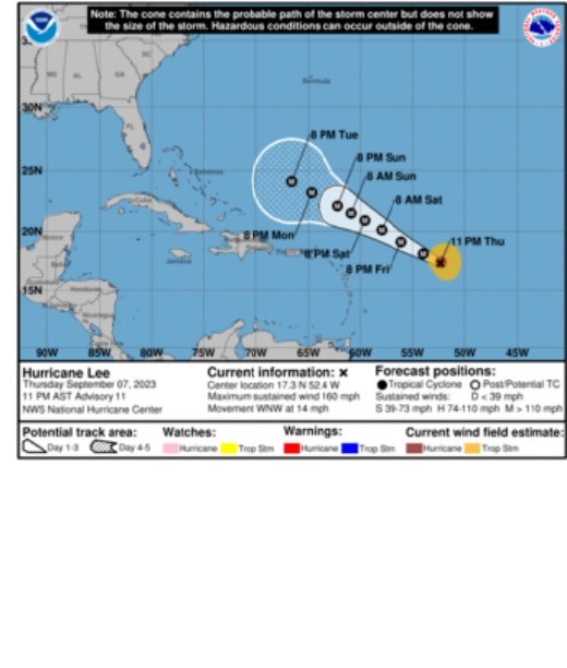
At present, meteorologists have not issued any coastal watches and warnings yet.
Forecast track
The center of Hurricane Lee was spotted near latitude 17.3 North, longitude 52.4 West.
The weather disturbance is moving towards the west-northwest near 14 mph (22 km/h) direction, and this motion is expected to continue even through early next week with a significant decrease in forward speed.
When it comes to the forecast track, Lee is expected to pass through the north of the northern Leeward Islands, the Virgin Islands, and Puerto Rico over the weekend up to early next week.
Meanwhile, information from an Air Force Reserve Hurricane Hunter aircraft has indicated that the maximum sustained winds of the hurricane have increased to near 160 mph (260 km/h) with higher gusts.
This prompted weather forecasters to categorize Lee as Category 5 hurricane based on the Saffir-Simpson Hurricane Wind Scale.
Meteorologists further warned of additional strengthening overnight while fluctuations when it comes to the intensity are likely over the next few days.
Still, Lee is expected to remain a major hurricane through early next week.
The hurricane-force winds is also expected to extend outward up to 45 miles (75 km) from the center and tropical-storm-force winds extend outward up to 140 miles (220 km).
On the other hand, the minimum central pressure based on dropsonde data is 928 mb (27.41 inches).
Read Also : Tropical Storm Lee Expected To Become A Major Hurricane; Meteorologists Alert Northeastern Carribean
Rip currents, risky surf
While it is still early to determine Lee's level of impacts in US East Coast, Atlantic Canada, and Bermuda, it is forecasted to bring rip currents across the northern Caribbean Bay as well as hazardous surf across the region.
Residents across mainland United States might feel Lee's impact by Sunday.
According to weather experts, the swells generated by Lee are expected to reach portions of the Lesser Antilles on Friday, and it will also be experienced by residents from the British and US Virgin Islands, Puerto Rico, Hispaniola, the Turks and Caicos Islands, the Bahamas, and Bermuda this weekend.
They explained that these swells are most likely to bring life-threatening surf and rip current conditions. These dangerous surf and rip currents are expected to begin along most of the US East Coast beginning on Sunday.
Meanwhile, authorities are also anticipating that some bands of heavy, gusty thunderstorms will develop well to the south of the main body of the hurricane.
This means squalls and stiffening winds will also progress through the islands from Friday night to Monday.
Moreover, the influx of tropical moisture and outer rain bands from Hurricane Lee is also projected to bring rainfall amounts ranging from one to two inches (25-50 mm) across the northern Leeward Islands from Friday night to Sunday.
Officials said that Lee is the 12th named storm of the Atlantic hurricane season, which usually occurs from June to November.
Due to the projected impact, US President Joe Biden has already been updated on its track and trajectory.
Related Article : Hurricane Lee Expected to Intensify Into Category 5; Deadly Rip Currents to Impact East Coast
Related Video:
© 2026 NatureWorldNews.com All rights reserved. Do not reproduce without permission.


