The latest weather forecast said severe weather conditions could emerge next week that could unload blizzard conditions, heavy snow, widespread thunderstorms and tornadoes in the Central United States.
The forecast explained that the storm could cause a life-threatening situation to property and lives. For many Americans, the early weeks of December would be chaotic as extreme weather conditions continued to persist in the country.
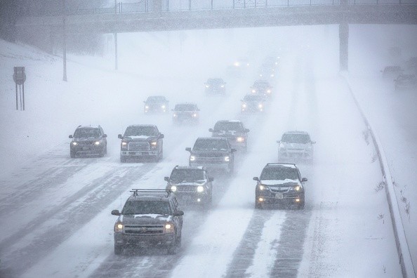
People in the affected areas should stay updated with the weather forecasts, especially since the storm could unleash dangerous blizzard conditions and tornadoes. Bringing an umbrella and raincoat is advisable as rounds of rain could unload this week.
According to the latest forecast on December 8, 2022, AccuWeather reported that the weather condition pattern for next week showed that severe weather conditions could emerge from Gulf Coast to Midwest. In addition, blizzard conditions could also occur. Meanwhile, heavy rain could unfold on East Coast and Northeast.
Next week will have small storms that could unload rain in portions of south-central. The forecast said that the storm could disrupt outdoor activities and travel.
Meanwhile, significant rain could unleash this coming weekend on the Pacific coast.
Severe Thunderstorms Starting on Monday
AccuWeather's forecast said it could unload severe thunderstorms from late Monday until Tuesday night as the storm organizes and becomes potent.
The forecast showed that tornadoes, hail, and torrential and damaging wind gusts could emerge. Starting Monday night, it will unload in Kansas City, Wichita, Oklahoma City, Dallas, Austin, Houston, New Orleans, Birmingham, St. Louis, Springfield, Little Rock and Shreveport.
In addition, severe thunderstorms could extend to the east, Great Lakes and Tennessee Valley starting Wednesday.
Drought-stricken Ohio and Mississippi Rivers could benefit from the severe thunderstorms with heavy rain. However, the forecast warned that it could cause small flooding.
AccuWeather warned that chance of tornadoes could occur on Tuesday afternoon, especially in portions of Interstate areas (20, 30, 40 and 55). Tornadoes are life-threatening, causing damage to buildings and homes.
The weather outlook showed that significant tornadoes could emerge on Tuesday in Jackson, Little Rock, Shreveport and Texarkana.
Potential Heavy Snow and Blizzard Conditions
As severe thunderstorms and weather conditions are concerns, AccuWeather's forecast revealed that blizzard conditions could emerge next week.
The storm, packed with moisture, could bring wintry and cold weather. AccuWeather explained that the cold air could mix with the storm, producing heavy snow. It could affect portions of the central Rockies and Northern Plains early next week.
The weather outlook showed that a snowstorm could emerge early next week, bringing blizzard conditions, strong winds and significant travel disruptions.
The forecast said blizzard conditions could be expected in Billings, Rapid City, Fargo, and Cheyenne portions.
- Blizzards could occur in Colorado, Dakotas, and Northern Minnesota from Tuesday until Wednesday.
- Potential Blizzard could also unfold in Rapid City, Scottsbluff, Aberdeen, Bismarck, Grand Forks, Fargo and Duluth from Tuesday until Wednesday.
The severe weather conditions could result in travel hazards and slow commutes. The forecast warned that difficult travel could emerge in corridors of Interstate 29, 90 and 94.
Related Article : Cold Weather to Remain Until Weekend in UK
For more similar stories, don't forget to follow Nature News.
© 2026 NatureWorldNews.com All rights reserved. Do not reproduce without permission.


