Forecasts showed that Tropical Storm Karl started to move to Mexico with tropical conditions in the southwestern portions.
Meteorologists are monitoring potential developments of a new storm in the Atlantic.
People near southwestern portions of Mexico, especially with tropical storm watches or warnings, should stay updated with current news and weather reports.
AccuWeather's latest update on October 14, said they were monitoring areas for any development in the coming weeks, noting that the Atlantic Hurricane wasn't over.
The article added that no tropical systems were detected over the next week; however, it may change depending on the weather's conditions.
The weather website explained that systems could form close to North America and Central America in the Atlantic Ocean, including in the southern Gulf of Mexico, the Atlantic Coast, and the Caribbean Sea.
It noted that they would closely monitor for potential development in the Caribbean for the next few weeks.
Mexico's Impact
Meanwhile, the National Hurricane Center's latest weather advisory on October 13, (10:00 p.m) showed that southwestern Mexico could experience tropical storm conditions starting late Friday.
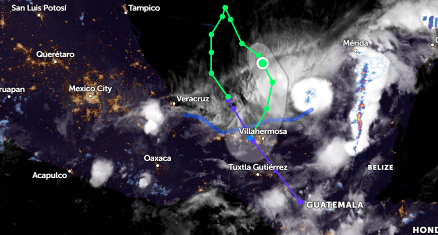
The advisory reminded heavy rainfalls could result in flash flooding, and mudslides in high-terrain areas, including in Tabasco, Chiapas, Veracruz, and Oaxaca states in Mexico.
Moreover, the Hurricane Center reported that Tropical Storm Karl was seen moving Southeastward on Campeche's Bay.
The NHC has been monitoring the developments on Tropical Storm Karl.
As of Thursday, reports said that Tropical Storm Karl recorded a near 50 mph (85 km/h) maximum sustained winds and higher gusts, noting that Karl could gradually weaken on Friday.
AccuWeather rated Tropical Storm Karl less than one on the RealImpactTM Scale for Hurricanes in Mexico, noting that the tropical storm could unleash locally damaging winds, rough surfs, flash flooding, rip currents, and mudslides.
Reports also showed that the tropical storm could not impact the United States.
Brace for Tropical Storm Karl's Impact
Forecasts reported that Tropical Storm Karl could make an impact starting late Friday.
Karl would unleash heavy rains that could result in mudslides, landslides, flash floods, and flooding. Rough and dangerous seas are also expected from the storm starting late Friday.
Keep in mind the following important reminders before Karl makes landfall.
- Tropical Storm Karl would unleash heavy rains. Tracking the storm with weather reports would help assess the impact on your communities. Keep your mobile phones waterproof.
- Stay on alert, especially near coastal areas or flood-prone places. Monitor the increase in seawater. Having a fully-charged mobile phone and a power bank would be very helpful for emergencies.
- Follow the advice of your local authorities for immediate evacuation, or consider evacuating early for the threat of a storm or Hurricane if the areas are flood-prone.
- Stay indoors sa much as possible during the onslaught of the storm.
- Lastly, advise your children or family to avoid traveling during the storm.
- After the storm, check your house for potential damage. Be careful with power lines or electrical supplies.
Related Article : Sea-Level May Rise to 2 Meters By 2100, Feared Critical to Existing Infrastructures in Asia Pacific Regions
For more similar, don't forget to follow Nature World News.
© 2026 NatureWorldNews.com All rights reserved. Do not reproduce without permission.


