There are tropical storm warnings for some of the Texas coast. AccuWeather analysts say a new tropical depression could develop as soon as this Friday in the southwest Gulf of Mexico.
Extreme Weather
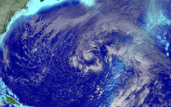
A large band of showers and thunderstorms connected to low pressure that was situated over the southwest Gulf of Mexico and the Bay of Campeche was becoming more organized, according to satellite imagery.
The tropical disturbance in the Gulf of Mexico has been named Potential Tropical Cyclone Four, according to the National Hurricane Center (NHC), which also announced that it would issue advisories as the system intensifies.
Tropical Storm Warning
A tropical storm warning was issued for the lower Texas coast from Port Mansfield south to the Rio Grande's mouth. Additionally, the Mexican government issued a tropical storm warning for the region extending from Boca de Catan northward to the Rio Grande Mouth.
According to meteorologists monitoring this area of the Atlantic basin for days, there was little time for the system to form. However, the system appears to remain long enough in warm waters, allowing it to strengthen and organize quickly.
AccuWeather forecasters have classified this developing system as a tropical rainfall. It is likely to intensify into a tropical depression or storm as of Friday.
The outlook for the upcoming days is predicted to be similar to the last few days. A tropical rainstorm that hit late last weekend and early this week dumped a lot of rain on South Texas and Mexico regions.
Storm Trajectory
According to AccuWeather Meteorologist Mary Gilbert, this tropical rainfall is passing over a region with high sea surface temperatures, which may provide a limited window for the system to intensify into a tropical depression or tropical storm by Saturday.
Regardless of the name, the rainfall will dump a lot of rain on parts of southern Texas and northeastern Mexico. Due to the possibility of flooding rainfall, this tropical rainstorm has been given a rating of less than one on the AccuWeather RealImpact Scale for Hurricanes for the United States and Mexico.
Gilbert stated that when a tropical rainstorm moves in from the western Gulf of Mexico, there will likely be significant rainfall across parts of eastern and northern Mexico and southern Texas. There will be an average rainfall of 1-2 inches (25-50 mm) across the region, with higher quantities of 2-4 inches (50-100 mm) near the eastern Mexican coast's immediate shoreline and higher terrain south of Monterrey. Local flash floods could result from this.
This year, the Atlantic basin's production of named storms has lagged somewhat behind schedule. Tropical Storm Colin, which developed early on Saturday, July 2, off the coast of South Carolina, was the last named storm to develop. Since Colin's demise over North Carolina the next day, no further named storms have developed.
Season Forecast
By August 15 in the Atlantic, the fourth named storm of a hurricane season often forms. Danielle is the next name on the NHC list to name storms.
The 2022 Atlantic hurricane season forecast from AccuWeather's meteorologists was updated on Thursday after being published in the spring. AccuWeather's team of long-range forecasters is now projecting a total of 16, which includes the three storms that have already formed, down from their earlier projection of 16 to 20 named storms.
AccuWeather Hurricane Expert Kottlowski said that the high likelihood of hurricanes with high impacts is our main concern as forecasters continue to predict a very active season for the 2022 Atlantic hurricane season.
Related Article : Exposure to Major Disasters Can Cause Long-Term Mental Health Problems
For more climate and weather updates, don't forget to follow Nature World News!
© 2026 NatureWorldNews.com All rights reserved. Do not reproduce without permission.


