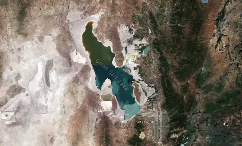
Utah's Great Salt Lake has shrunk, according to satellite photographs. According to startling new photos, the lake has lost over half of its surface area compared to the historical norm.
Hitting Record Lows
A month after the Great Salt Lake in Utah reached its lowest water level ever recorded, new satellite photographs from the have shown the lake's declining water levels.
The paper contrasts satellite pictures from 1985 and 2022, emphasizing the declining water levels and the shrinking lake. It had a surface area of around 3,300 sq miles at its height in the 1980s; however, recent measurements show that it has lost approximately half that amount. Last month's new record was the second historical low to be attained in less than a year.
Experiencing Megadrought
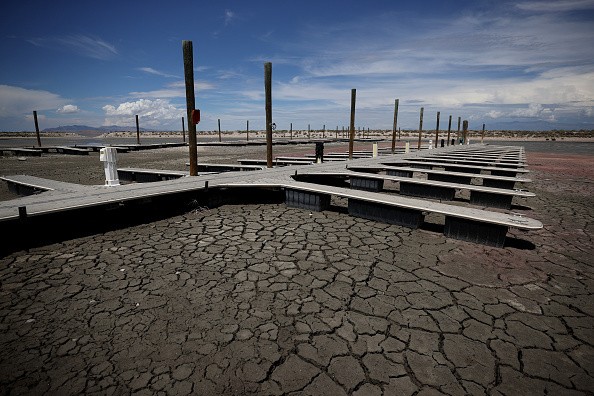
According to statistics from the US Geological Survey, the southwest of the US has been experiencing a megadrought that has exposed roughly 770 square miles of the lakebed.
The drought brought on by climate change and water consumption, as well as the diversion of water from streams that refilled the lake for use in homes and farms, have all been blamed for the lake's extinction.
As Utah's population has grown, there is a greater need for water in the lake. Its population of over 3.3 million is expected to expand by almost 50% by 2060, making it the US state with the highest population growth.
The lake is home to a variety of animals, and along with the nearby wetlands, it also hosts over 10 million migrating birds annually. The lake provides a feeding ground for around 330 species but is presently endangered due to growing salinity levels.
The dwindling lake not only puts animals in jeopardy but also in human health. Exposure to the lakebed causes the emission of dust that contains hazardous byproducts of local mining operations, including copper and arsenic, which can be blown onto surrounding communities and cause lung issues if breathed.
According to officials, the lake is anticipated to keep becoming smaller until at least early winter, when snow and rain will start to restore some of the water lost.
Affecting Everyone and Everything
Due to historically low water levels, migratory birds, residents, and economic growth are all in significant danger.
When it was last measured in October 2021, Utah's Great Salt Lake had dropped below historical levels less than a year earlier. The lake's average daily surface water elevation was 4,190 feet on July 3 after water levels were gauged. The lake was 4,200 feet above sea level in 1847 when measurements started being made; therefore, it has dropped by almost 10 feet since then. The Great Salt Lake's current maximum depth is only 30 feet. According to Gizmodo's Lauren Leffer, the lake's surface size was 3,300 square miles in the 1980s but is currently fewer than 1,000.
The volume of incoming water to the lake must equal or surpass evaporative losses by autumn or early winter, according to historical data, according to a statement from the United States Geological Society. The lake experiences cyclical cycles of water loss and replenishment after being refilled by rain and snowmelt. According to Gizmodo, torrents that once drained into the lake basin were instead redirected to serve the demands of business, agriculture, and people.
Related Article : Air Quality in Great Salt Lake May Turn Hazardous Due to Pollution
For similar news, don't forget to follow Nature World News!
© 2026 NatureWorldNews.com All rights reserved. Do not reproduce without permission.


