According to recent research, the megaberg A68A melted over three months in 2020/2021, releasing 152 billion tons of fresh water into the oceans around the sub-Antarctic island of South Georgia, equivalent to 20 times the volume of Loch Ness or 61 million Olympic-sized swimming pools.
Breaking Off

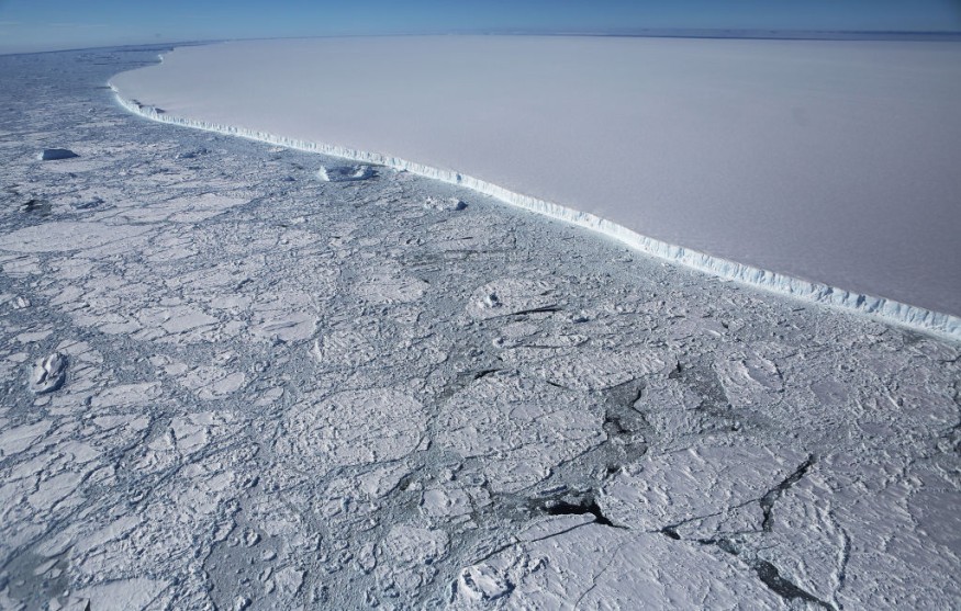
The A68A iceberg broke off the Larsen-C Ice Shelf on the Antarctic Peninsula in July 2017 and embarked on a 3.5-year, 4,000-kilometer trek across the Southern Ocean. It was the largest iceberg on Earth when it formed, measuring 5719 square kilometers-roughly one-quarter the size of Wales-and the sixth-largest on record.
The berg attracted global attention around Christmas 2020, as it traveled dangerously near South Georgia, sparking worries that it may endanger the island's fragile environment.
Satellite measurements were utilized by researchers from the Centre for Polar Observation and Modelling (CPOM) and the British Antarctic Survey (BAS) to record the A68A iceberg's area and thickness change over time. The berg had melted sufficiently as it traveled, according to the authors, to escape damage to the sea bottom surrounding South Georgia by running aground.
However, due to the melting, a massive 152 billion tons of fresh water were released close to the island, causing a disruption that might significantly influence the island's marine ecology.
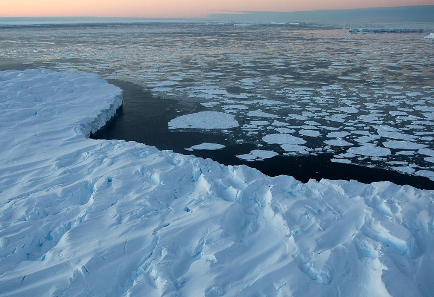
A68A spent the first two years of its life in the icy waters of the Weddell Sea, near Antarctica, and experienced little melting. However, when it made its way north via the Drake Passage, it encountered more warm seas and began to melt.
The iceberg decreased by 67 meters from its original 235-meter thickness, with the pace of melting increasing dramatically as it traveled past South Georgia in the Scotia Sea.
"A68 was a fascinating iceberg to track from its creation to its end," said Laura Gerrish, a BAS GIS and mapping specialist and co-author of the study. "Frequent measurements allowed us to follow every move and break-up of the berg as it moved slowly northward through iceberg alley and into the Scotia Sea, where it then gained speed and approached the island of South Georgia very closely."
Related Article : Antarctica's Doomsday Glacier at Risk of Collapsing, Could Permanently Change Global Coastline
Stranded on the Seabed
If the keel of an iceberg is excessively deep, it might become stranded on the seabed. This may cause problems in several ways: the scour scars can kill animals, and the berg itself can obstruct ocean currents and predator feeding pathways. When A68A neared South Georgia, all of these scenarios were feared.
However, according to this current study, it only crashed with the sea floor for a few seconds before breaking apart, posing less blockage danger. The iceberg's keel was lowered to 141 meters below the ocean surface when it reached the shallow seas surrounding South Georgia, shallow enough to avoid the seafloor, which is roughly 150 meters deep.
Nonetheless, the huge iceberg's presence would undoubtedly have influenced the environment and species of South Georgia. When icebergs break free from ice shelves, they float with the currents and wind, releasing cool fresh meltwater and nutrients as they melt.
This technique affects local water circulation and promotes biological production in the vicinity of the iceberg. The iceberg melted at a pace of 7 meters per month at its height, releasing 152 billion tons of fresh water and nutrients in the process.
The study's principal author is Anne Braakmann-Folgmann, a CPOM researcher and Ph.D. candidate at the University of Leeds' School of Earth & Environment.
"This is a massive amount of melt water," she said, "and the next thing we want to know is whether it had a positive or negative impact on the ecosystem around South Georgia. Because A68A took a common route across the Drake Passage, we hope to learn more about icebergs that follow a similar path and how they influence the polar oceans."
Satellite Observations
Observations from five satellites were used to map A68A's path. A mix of Sentinel-1, Sentinel-3, and MODIS data was used to track the iceberg's area change. Meanwhile, CryoSat-2 and ICESat-2 altimetry were used to assess the iceberg's thickness change. The iceberg's size, thickness, and volume change were calculated by combining these observations.
"Our ability to study every move of the iceberg in such detail is thanks to advances in satellite techniques and the use of a variety of measurements," said Tommaso Parrinello, CryoSat Mission Manager at the European Space Agency.
"Imaging satellites record the location and shape of the iceberg, and data from altimetry missions add a third dimension by measuring the height of surfaces beneath the satellites and can thus observe how an iceberg melts."
For similar news, don't forget to follow Nature World News!
© 2026 NatureWorldNews.com All rights reserved. Do not reproduce without permission.


