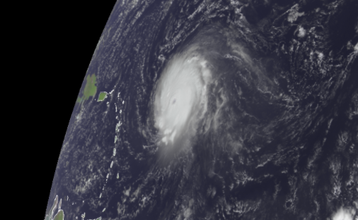
As Florida's National Hurricane Center (NHC) continues to track category 4 Major Hurricane Sam, three more cyclones could hit in the Atlantic in the coming days.
Hurricane Sam is still packing maximum sustained winds of 130 mph after yesterday's peak. Fortunately, the storm was contained over water and did not bring threat or damage to land. Miami's NHC latest forecasts says the storm steers away from the Northern Leeward Islands and the Bahamas, but brings it "dangerously close to Bermuda by next weekend".
The Five-Day Graphical Tropical Weather Outlook provided by the NHC have not exactly told Sam's next expedition.
First Area of Concern: North Atlantic
Meanwhile, the latest Tropical Outlook from National Hurricane Center shows three more disturbances that could potentially turn into tropical cyclones within the week in the Atlantic hurricane basin. The first was tracked in the North Atlantic well north of Sam and the other two are behind it in the eastern Atlantic.
The first area of concern in North Atlantic, also associated with the remnants of Tropical Storm Peter formed late Saturday well northeast of the Leeward Islands, is associated with a system of low-pressure area, currently located a few hundred miles east-southeast of Bermuda.
Although there is only little change in the organization of showers and thunderstorms associated with this system since the other day, the environmental conditions seem slightly conducive for further development, NHC reported. In fact, Peter could also shortly become a tropical depression again during the next day or two as it moves northeastward near 10 mph. The environmental conditions are expected to remain unfavorable for further development by the middle of the week.
Of the three potential system, this first area have the 'lowest odds', according to NHC, with only 50-50 shot of formation over the next 48 hours.
The Two Other Potential Systems: Eastern Atlantic
The second area several hundred miles southwest of the Cabo Verde Islands showed disorganized showers and thunderstorms, associated with a broad area of low pressure and likely to become a tropical cyclone.
Unlike the first one, "environmental conditions are forecast to be conducive for further development of this disturbance, and a tropical depression is likely to form in a few days while it moves westward to west-northwestward at 5 to 10 mph over the central tropical Atlantic," according to NHC. "While there's only a 40% chance of formation over the next 48 hours, there's a high 80% chance that it will form over the next five days."
Lastly, the third area of concern is just off the west coast of Africa. It exhibited upper-level winds, conducive for gradual development of a tropical wave as it moves off the coast. "A tropical depression is likely to form in a few days while the system moves westward to west-northwestward at 10 to 15 mph over the far eastern tropical Atlantic. Like the other system just to its west," NHC reports, noting 40% chance of formation over the next 48 hours, to a high 80% over the next five days.
© 2026 NatureWorldNews.com All rights reserved. Do not reproduce without permission.


